Table of Contents
- 1. Rediscovering Teotihuacan’s Southern Sacred Anchor
- 2. The Tri-Phase Bridge: Survival Across Millennia
- 3. Decoding the Divine Weather Machinery
- 3.1. The Storm God (Tlaloc Ancestor)
- 3.2. The Water Goddess (Chalchiuhtlicue Ancestor)
- 3.3. Sacred Spatial Placements
- 4. Unlocking the Year-Bearer Calendar Dates
- 5. The Eternal Legacy of Mountain Worship
- 6. Frequently Asked Questions
- 6.1. What major discovery was made at Cerro Patlachique?
- 6.2. Where is Cerro Patlachique located?
- 6.3. Which ancient deities are represented on the stone monuments?
- 6.4. What do the calendar dates on the stones signify?
- 6.5. Did the shrine close after the collapse of Teotihuacan?
Sacred Summit Discovered Above Teotihuacan Rewrites Mesoamerican History
A breathtaking archaeological breakthrough high above the Valley of Mexico has unveiled a forgotten sacred landscape that guarded the southern flank of one of antiquity’s greatest metropolises. While the monumental Pyramids of the Sun and Moon in the urban center of Teotihuacan (circa 150–550 CE) have historically monopolized global scientific attention, a major new study has shifted focus to the rugged peaks framing the valley.
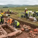
Through a combination of advanced laser mapping and systematic field exploration on the summit of Cerro Patlachique, an international team of researchers has exposed a massive, long-lived pilgrimage shrine. The complex features a temple, massive water reservoirs, a paved ceremonial avenue, and an extraordinary corpus of 40 carved stone monuments. Dating from before the rise of the city to long after its mysterious collapse, this high-altitude sanctuary proves that the ancient peoples of the valley extended their spiritual world deep into the surrounding mountains, using the peak as a grand outdoor stage to track sacred time, pray for life-giving rain, and encode divine presence into the living rock.

Sacred Summit Discovered Above Teotihuacan Rewrites Mesoamerican History
Rediscovering Teotihuacan’s Southern Sacred Anchor
The pioneering research on the mountain, published in the journal Antiquity, was carried out by an elite team of scholars including N. Sugiyama, K. A. Taube, S. Sugiyama, and A. Texis Muñoz. Their fieldwork recorded 34 previously completely unknown, unpublished stone monuments alongside an existing corpus of six, all clustered tightly around the windy summit of Cerro Patlachique.
To map the high-altitude architecture, researchers utilized airborne Lidar (Light Detection and Ranging), a laser scanning technology that penetrates thick mountain vegetation to expose hidden masonry. The resulting digital models exposed a highly organized ritual complex.
       [TEOTIHUACAN VALLEY SACRED VERTICAL AXIS]

         [NORTHERN ANCHOR]  ──> Cerro Gordo (The Water Mountain)
                │
                ▼
         [URBAN VALLEY CORE] ──> Pyramids of the Sun and Moon
                ▲
                │
         [SOUTHERN ANCHOR]  ──> Cerro Patlachique (The New Shrine)
The builders of the shrine carefully leveled the mountain topography to construct a prominent temple, engineered water containment basins, and laid out a grand processional avenue. Amazingly, the entire layout adheres to the precise, idiosyncratic architectural alignment found within the city grid of Teotihuacan itself, proving that the mountain complex was intentionally designed to harmonize with the urban heart of the valley.
The Tri-Phase Bridge: Survival Across Millennia
Analysis of broken ceramic vessels scattered across the summit reveals that Cerro Patlachique possessed a spiritual longevity that outlasted the city itself. Rather than being a short-lived satellite outpost, the sanctuary acted as a sacred chronological bridge spanning three distinct eras of Mesoamerican history:
The Pre-Urban Phase: Initial ritual activity and pottery deposition began during the infancy of regional urbanization, long before the first stone of the Great Pyramids was laid.
The Classic Period: The shrine reached its architectural zenith during the height of Teotihuacan’s imperial dominance, receiving state-sponsored artistic upgrades.
The Post-Classic Era: Following the violent fire and collapse of Teotihuacan around 550 CE, incoming migratory groups—including the ancestors of the Aztecs—continued to make perilous pilgrimages up the mountain to leave offerings, proving the peak’s inherent holiness independent of state control.
Decoding the Divine Weather Machinery
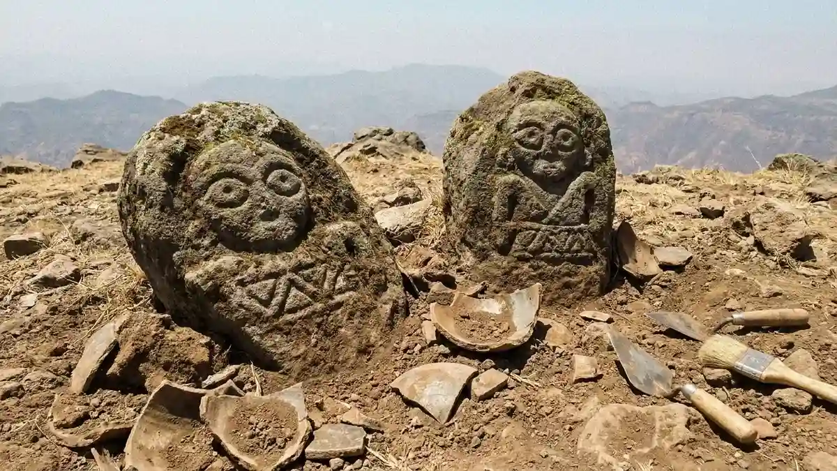
The stone monuments scattered across the summit are a mix of massive volcanic boulders carved directly in situ (in their original place) and smaller, high-quality stones that were manually hauled up the steep ridges. A rigorous iconographic analysis of these carvings revealed an obsessive focus on two primary Mesoamerican water deities:
The Storm God (Tlaloc Ancestor)
Documented across nine individual carvings, this male deity is instantly recognizable by his signature “goggle eyes,” mustache-like upper lip, and protruding, fanged mouth. He represents the raw, explosive celestial power of thunderstorms, lightning, and dark rainclouds.
The Water Goddess (Chalchiuhtlicue Ancestor)
Identified on three distinct stone monuments, she represents terrestrial water—the living currents flowing through rivers, underground springs, and mountain streams.
               [THE WATER CONVERGENCE SYSTEM]
                             │
     ┌───────────────────────┴───────────────────────┐
     ▼                                               ▼
 THE STORM GOD                             THE WATER GODDESS
 (9 Summit Carvings)                       (3 Summit Carvings)
 Celestial Rain & Thunder                  Terrestrial Springs & Rivers
     │                                               │
     └───────────────────────┬───────────────────────┘
                             ▼
         [3 JOINT MONUMENTS: COSMIC HARMONY & REBIRTH]
In three extraordinary instances, the Storm God and the Water Goddess are carved together on a single stone block. This pairing symbolizes the perfect dual harmony of celestial and terrestrial moisture forces, linking the physical mass of the mountain directly with the arrival of seasonal summer monsoons that watered the agricultural fields below.
Sacred Spatial Placements
The positioning of these divine images across the mountain landscape was far from random. The carvings of the rain gods are systematically clustered to the east of the primary ceremonial avenue, sitting directly at the drainage heads of natural, seasonal mountain streams. By placing the stone gods at the exact points where rainwater first collected before racing down into the valley, ancient priests metaphorically transformed the entire mountain into a massive, living fountain of divine blessing.
| Monument Attribute | Elite State Style | Pilgrim / Folk Style |
| Execution Quality | Finely ground, deep relief, sharp geometric boundaries | Rough, shallow incisions, individualistic, fluid lines |
| Sponsorship | Commissioned by the Teotihuacan state government | Executed by private families, local shamans, or lone travelers |
| Cultural Purpose | Projects official state theology and imperial power | Expresses intimate, localized personal devotion and private vows |
The striking variation in carving styles proves that the mountain was a highly democratic space. While fine, state-commissioned Classic Teotihuacan artworks stood along the main avenues, rougher, deeply personal carvings filled the secondary spaces. One fascinating boulder shows a rougher, later engraving physically superimposed directly on top of an older, elegant Classic design—dramatic proof that generations of everyday pilgrims returned to the mountain, rewriting their own personal stories onto the ancestral sacred stone.
Unlocking the Year-Bearer Calendar Dates
Perhaps the most scientifically revolutionary aspect of the Cerro Patlachique discovery is the presence of explicit chronological dates carved into the stone monuments. Thirteen of the boulders bear distinct glyphs and numeric dots belonging to the famous 260-day Mesoamerican ritual calendar.
+-------------------------------------------------------------+
|               THE CALENDRICAL ANCHOR SYSTEM                 |
|                                                             |
|   • Total Dated Carvings:  13 Distinct Inscribed Monuments  |
|   • Core Matrix:           260-Day Sacred Ritual Cycle      |
|   • Year-Bearer Marks:     8 Markers of the Solar Calendar  |
|   • Meaning:               Tracking cosmic time on high     |
+-------------------------------------------------------------+
Crucially, at least eight of these carvings refer to specific year-bearer day names—the rare, highly important calendar signs that marked the starting day of the 365-day solar year. Finding these highly complex chronological markers carved directly onto the mountain peaks provides historians with a vital new dataset for reading how the city-dwellers calibrated their astronomical cycles. The high summit acted as a giant natural sundial and observational platform, where priests could align the rising or setting sun against distant horizons to dictate the exact days to plant crops, execute state ceremonies, or launch military campaigns.
The Eternal Legacy of Mountain Worship
The documentation of Cerro Patlachique successfully completes a massive missing piece of the Teotihuacan geographic puzzle. For decades, archaeology focused heavily on Cerro Gordo, the massive mountain flanking the city’s northern boundary. This new research proves that Cerro Patlachique served as its intentional southern counter-weight, creating a flawless, sacred vertical axis directly across the heart of the valley.
Ultimately, the discoveries on the peak remind us that ancient Mesoamerican cities were not self-contained blocks of concrete and stone. To the residents of Teotihuacan, the natural landscape was a living, breathing extensions of their temples. Cerro Patlachique stands as a monument to human endurance and faith—a sky-high sanctuary where carved stones successfully kept watch over the passage of cosmic time, the changing of the seasons, and the shifting destinies of one of the New World’s greatest imperial cultures.
Frequently Asked Questions
What major discovery was made at Cerro Patlachique?
Archaeologists uncovered a massive, long-lived pilgrimage sanctuary featuring a temple, water reservoirs, a processional avenue, and a corpus of 40 carved stone monuments hidden on the high summit.
Where is Cerro Patlachique located?
Cerro Patlachique is a prominent mountain peak rising high above the southern edge of the Teotihuacan Valley in central Mexico, serving as the southern geographical anchor to the ancient city.
Which ancient deities are represented on the stone monuments?
The carvings focus heavily on ancient water and agricultural deities, including nine depictions of the goggle-eyed Storm God and three images of the Water Goddess, who together regulated rainfall and mountain springs.
What do the calendar dates on the stones signify?
Thirteen monuments feature explicit dates from the 260-day ritual cycle, with eight referencing “year-bearer” day names. These carvings prove the summit was a vital astronomical and calendrical locus used to track the 365-day solar year.
Did the shrine close after the collapse of Teotihuacan?
No. Ceramic evidence proves that the shrine was established in the pre-urban phase before the city’s rise, flourished during the Classic period, and remained an active pilgrimage destination for centuries during the Post-Classic era after the city’s decline.