Table of Contents
- 1. Mapping Prehistoric Art: A Modern Technological Approach
- 2. The Prehistoric Swiss Army Knife of Seafaring Design
- 2.1. Anatomical Similarities in Hull and Rigging
- 2.2. Decorative Identifiers
- 3. Chronology and the Importance of the Iberian Metal Trade
- 3.1. The Tin Trails of Penedo do Muro
- 4. Sun Crosses: A Shared Cosmological Religion
- 5. A New Frontier in Atlantic European History
- 6. Frequently Asked Questions (FAQ)
- 6.1. What are petroglyphs and why are they important?
- 6.2. How did scientists find these hidden carvings?
- 6.3. What do the similarities in boat carvings mean?
- 6.4. Why was northwest Iberia important to ancient Scandinavian traders?
- 6.5. What is a sun cross and what did it represent?
Bronze Age Boat Carvings Rewrite History of Ancient European Sea Networks
A revolutionary archaeological study has unveiled an astonishing truth about the ancient world: European coastal communities were deeply interconnected by vast, long-distance maritime highways more than 3,000 years ago. By analyzing prehistoric rock art preserved across centuries, researchers have identified shocking visual links between the Iberian Peninsula and southern Scandinavia.
This breakthrough directly challenges previous historical models of localized, isolated Bronze Age societies, proving instead that seafaring technology, sophisticated commercial trade, and complex cosmological beliefs were fluidly exchanged across thousands of miles of rough Atlantic waters.

Bronze Age Boat Carvings Rewrite History of Ancient European Sea Networks
 The Archaeology of Portugal Fellowship
Mapping Prehistoric Art: A Modern Technological Approach
The groundbreaking discovery relies on a meticulous comparative analysis of prehistoric rock carvings, scientifically known as petroglyphs. An international team of archaeologists focused their field research on 12 distinct rock art sites scattered throughout northwest Iberia—a region encompassing modern-day northern Portugal and northwestern Spain. They contrasted these Iberian petroglyphs with thousands of well-documented nautical carvings located in southern Scandinavia.
To ensure the accuracy of their observations, the scientific team moved away from traditional hand-drawn rubbings and photographs. Instead, they deployed a suite of cutting-edge geospatial and digital imaging technologies:
High-Resolution 3D Scanning: Capturing the precise millimetric depth, groove angles, and structural contours of the eroded rock faces.
Reflectance Transformation Imaging (RTI): Enhancing surface topography digitally to reveal hidden or heavily weathered carvings that are completely invisible to the naked human eye under normal sunlight.
Geographic Information Systems (GIS): Spatial mapping software used to evaluate the precise positioning of the rock art panels relative to ancient water channels, shorelines, and localized mineral topography.
The results of this technological approach allowed researchers to directly overlay the Iberian motifs with Scandinavian datasets, confirming a level of anatomical and artistic correlation that stunned the research community.

The Prehistoric Swiss Army Knife of Seafaring Design
The petroglyphs analyzed across both distant regions display an identical understanding of maritime engineering and naval design. Rather than abstract stick figures representing generic boats, the carvings illustrate sophisticated, multi-component ships.
Anatomical Similarities in Hull and Rigging
The 3D scans exposed that the prehistoric artists from Iberia and Scandinavia were drawing the exact same physical boat structures. The carved vessels feature prominent curved hulls, distinct crew configurations, aligned oars, functional masts, and intricate rigging frameworks associated with early sail configurations.
Decorative Identifiers
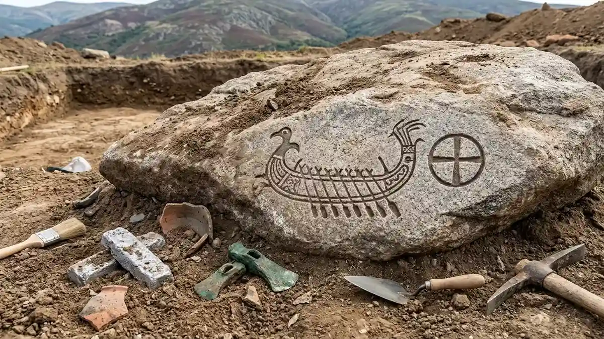
Beyond basic functional engineering, the stylistic and decorative treatments of the carved vessels are virtually indistinguishable. Both Iberian and Scandinavian ship carvings frequently feature distinctive avian figures (bird motifs) and stylized S-shaped flourishes ornamenting the prows and sterns of the vessels.
This level of stylistic symmetry indicates that these societies did not merely build similar functional boats out of environmental necessity; they shared a deeply rooted, highly specific artistic and symbolic lexicon. It suggests that shipwrights from Iberia and Scandinavia were operating within a shared technological tradition, passing blueprints, construction methods, and maritime aesthetics along a continuous Atlantic network.
Chronology and the Importance of the Iberian Metal Trade
The comparative data firmly places the execution of the majority of the northwest Iberian boat carvings within the Late Bronze Age, specifically between 1300 and 800 BCE. This chronological window lines up precisely with a massive boom in maritime activity and nautical rock art production observed across southern Scandinavia.
+-------------------------------------------------------------------------+
|                  THE BRONZE AGE ATLANTIC MARITIME NETWORK               |
+--------------------+----------------------------------------------------+
| Region             | Primary Role & Contribution                        |
+--------------------+----------------------------------------------------+
| Northwest Iberia   | Resource-rich hub; prime producer of high-grade    |
|                    | tin essential for alloying bronze weapons.         |
+--------------------+----------------------------------------------------+
| Southern           | Maritime superpower; possessed high-capacity      |
| Scandinavia        | seafaring vessels and dense coastal networks.      |
+--------------------+----------------------------------------------------+
| Atlantic Highways  | Thousands of miles of open ocean routes utilized   |
|                    | for transferring ideas, art, and beliefs.          |
+--------------------+----------------------------------------------------+
The physical positioning of these carvings across the landscape reveals a deliberate geographic strategy. The vast majority of the petroglyphs are situated in high-visibility locations overlooking ocean estuaries, major navigable river mouth systems, and protected coastal landing spots.
The Tin Trails of Penedo do Muro
While many carvings hug the Atlantic coastline, significant clusters were found deeper inland, positioned along rivers that directly feed into the ocean. The most telling example is the inland site of Penedo do Muro. This valley was a prehistoric goldmine for tin extraction—one of the most critical and highly sought-after commodities of the Bronze Age, required to alloy with copper to forge durable weapons, tools, and prestige items.
The rock panels at Penedo do Muro feature clear boat layouts that mirror southern Scandinavian rock art style. The presence of these nautical designs deep within a mineral-rich mountain valley proves that ancient international traders and foreign sailors were not merely skimming the coastlines. Instead, they were navigating deep into river valleys, moving inland to secure critical metallurgic resources, exchange raw materials, and integrate with local Iberian communities.
Sun Crosses: A Shared Cosmological Religion
The connection between Iberia and Scandinavia extended far beyond material commerce and technological exchange. The rock art reveals an ideological and religious alliance that bound these distant maritime communities together under a unified belief system.
At multiple Iberian locations, archaeologists identified sun crosses (a circle intersected by a cross) carved immediately adjacent to the boat motifs. This specific pairing—the solar disc accompanied by a celestial vessel—is the defining theological hallmark of the Scandinavian Bronze Age, famously epitomized by artifacts like the Trundholm Sun Chariot.
The repeated, deliberate pairing of these two symbols across both regions demonstrates that for Late Bronze Age communities, ships held a profound metaphysical significance that went far beyond basic travel or merchant logistics. The vessels were treated as sacred vehicles tied to solar cults, representing the symbolic journey of the sun across the heavens and the journey of the soul through the afterlife. This shared spirituality suggests that a standardized, pan-European maritime religion dominated the Atlantic coastlines for centuries.
A New Frontier in Atlantic European History
The comprehensive findings confirm that northwest Iberia was not a peripheral backwater, but a vibrant, highly influential epicenter within a sprawling pan-European maritime alliance. The Atlantic coast of Europe functioned as a completely connected economic and cultural zone, where the constant circulation of ships carried copper, tin, technology, and artistic styles across thousands of miles of open ocean.
As this international research project enters its next phase, scientists are preparing to launch localized chemical and isotopic analysis of surviving Bronze Age metal artifacts found across Europe. By tracing the exact geologic origin of the tin and copper used in Scandinavia, they hope to map out the precise trade routes utilized by these prehistoric sailors, permanently changing our understanding of humanity’s earliest seafaring global networks.
Frequently Asked Questions (FAQ)
What are petroglyphs and why are they important?
Petroglyphs are images, symbols, or designs created by carving, scratching, or engraving directly onto natural rock surfaces. In prehistoric research, they are invaluable because they provide a permanent, visual record of a society’s technological capabilities, daily activities, and spiritual belief systems before the invention of written text.
How did scientists find these hidden carvings?
Archaeologists used a combination of modern imaging tools, including high-resolution 3D scanning and Reflectance Transformation Imaging (RTI). RTI uses a series of photographs taken from different light angles to map out the microscopic texture of the rock, allowing researchers to see weathered designs that are completely invisible to the human eye under normal daylight.
What do the similarities in boat carvings mean?
The anatomical similarities—including identical curved hulls, oar arrangements, masts, rigging configurations, and decorative bird prows—prove that Late Bronze Age communities in Spain, Portugal, and Scandinavia shared an identical tradition of shipbuilding. This indicates regular, direct contact and a fluid exchange of technological knowledge across long distances.
Why was northwest Iberia important to ancient Scandinavian traders?
Northwest Iberia was exceptionally rich in vital mineral deposits, particularly high-grade tin. Because tin was an essential ingredient required to combine with copper to manufacture bronze, international maritime traders sought out these river valleys to trade luxury items for raw metallurgical components.
What is a sun cross and what did it represent?
A sun cross is a prehistoric symbol consisting of a cross enclosed within a circle. When carved next to ancient ships, it represented a widely shared, pan-European solar religion. Ancient people believed that the sun was carried across the daytime sky and through the dark underworld at night by a sacred celestial boat.