
Table of Contents
- 1. The Stratified Military Legacy of Gullberget Hill
- 2. Blending High-Tech Archaeology with Historical Mystery
- 2.1. Mapping Subterranean Traces
- 2.2. Balancing Fact and Scientific Interpretation
- 3. Step Inside 1612: An Immersive Virtual Experience
- 4. Gullberg’s Stronghold and the Master Plan of Gothenburg
- 4.1. The Canals: Arteries of Defense and Commerce
- 5. Preserving the Intangible Past Through Digital Preservation
- 6. Frequently Asked Questions (FAQ)
- 6.1. What was Gullberg’s Fäste?
- 6.2. What is the relationship between Gullberg’s fort and Skansen Lejonet?
- 6.3. How did archaeologists create the 3D model of a destroyed building?
- 6.4. How can the public view this 3D reconstruction?
- 6.5. Why was Gothenburg built with canals and a strict grid layout?
3D Tech Resurrects Destroyed 17th-Century Swedish Border Fortress Today
A lost piece of European military history has been pulled from the shadows of time and brought back to life in stunning digital detail. Following nearly a decade of intense field research, a dedicated team of Swedish archaeologists has officially released a comprehensive 3D reconstruction of Gullberg’s Fäste (Gullberg’s Stronghold). This massive 17th-century bastion once stood as a vital shield on Gothenburg’s Gullberget Hill before it was completely leveled during a brutal foreign siege.
The digital revival allows modern viewers to experience the complex fortification exactly as it stood in 1612—mere months before a catastrophic Danish military assault reduced its wooden towers and stone walls to ash. By merging cutting-edge field data with historical archives, this ambitious project offers an unprecedented look into early Scandinavian warfare, urban evolution, and defensive architecture.
3D Tech Resurrects Destroyed 17th-Century Swedish Border Fortress Today

The Stratified Military Legacy of Gullberget Hill
To understand the strategic value of Gullberg’s Stronghold, one must understand the unique geography of Gothenburg. Today, Gullberget Hill is widely celebrated as the home of Skansen Lejonet (The Lion Redoubt), a iconic, crown-topped stone tower that has dominated the city’s skyline for roughly 350 years. However, the military importance of this rocky outcrop extends far deeper into the past than the standing tower suggests.
Long before the modern city of Gothenburg was even conceived, Gullberget Hill served as a vital lookout point over the mouth of the Göta River—a hotly contested waterway that formed a natural border zone between competing Nordic kingdoms.
14th Century: The very first primitive fortifications are erected on the hill to secure regional trade lines.
16th and 17th Centuries: As geopolitical tensions escalated between Sweden and Denmark, these early structures were heavily expanded, evolving into the formidable border stronghold known as Gullberg’s Fäste.

The fort served as a primary line of defense, absorbing the brunt of enemy incursions and protecting the vital economic gateways of the Swedish west coast.
Blending High-Tech Archaeology with Historical Mystery
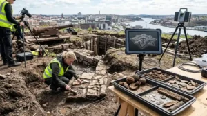
The creation of the 3D model was not a matter of artistic guesswork. It was the culmination of seven years of meticulous, hands-on rescue archaeology conducted by the specialized research agency Arkeologerna.

Mapping Subterranean Traces
During extensive field excavations on Gullberget Hill, field teams utilized a suite of sophisticated geospatial documentation technologies to capture every remaining millimeter of the fort’s foundations. Two primary methods were critical to this process:
Terrestrial Laser Scanning: This technique shoots millions of light points per second to create hyper-accurate, three-dimensional “point clouds” of the surviving stone footings and subterranean trenches.
Photogrammetry: By overlapping hundreds of high-resolution aerial and ground-level photographs, researchers stitched together textured digital models that capture the exact color, depth, and structural wear of the excavated features.
Balancing Fact and Scientific Interpretation
Archaeologists then cross-referenced these highly accurate digital footprints with a massive collection of primary documents, including original 17th-century military maps, engineering blueprints, contemporary texts, and early artistic sketches.
Mikael Lindahl, the digital modeling expert who spearheaded the 3D visualization project at Arkeologerna, emphasized that reconstructing a destroyed site requires a careful balance between hard empirical data and educated archaeological interpretation. The goal was to ensure that while missing elements had to be filled in using historical parallels, every single line of the model remained firmly anchored in scientific probability.
Step Inside 1612: An Immersive Virtual Experience
The final digital asset is completely accessible to the global public through a web-based, 360-degree interactive interface. Rather than looking at static diagrams, users can digitally walk through the historical stronghold on their mobile devices or computers.
The immersive simulation guides users through several key zones of the lost fortress:
The Deep Tower Basements: Descend into the subterranean storage chambers where gunpowder, food reserves, and heavy munitions were protected from incoming artillery fire.
The Defensive Ramparts: Walk along the elevated parapets and defensive walls to the position of a reconstructed wooden guardhouse, experiencing the exact sightlines 17th-century soldiers used to scout for approaching enemy forces.
The Reconstructed Historic Landscape: Look out beyond the heavy timber walls to observe a digitally recreated version of the surrounding 17th-century landscape, capturing the pristine wetlands, river channels, and early settlements exactly as they appeared before modern urbanization took hold.
This digital experience has been fully integrated into local heritage tourism. Visitors physically standing at the modern Skansen Lejonet monument can scan strategically placed QR codes to instantly overlay the 1612 virtual fort onto their current surroundings. Additionally, after successful runs as featured exhibits at the Gothenburg City Museum and Stockholm’s Swedish History Museum, the model continues to educate the public on early Scandinavian heritage.
Gullberg’s Stronghold and the Master Plan of Gothenburg
The digital resurrection of Gullberg’s Fäste serves a much larger historical narrative: visualizing the grand urban planning project that birthed modern Gothenburg.
Following the definitive destruction of Gullberg’s fort and nearby settlements by Danish forces, King Gustavus Adolphus officially established the fortified city of Gothenburg in 1621. The sovereign recognized that to secure a permanent, unbreakable foothold on the western coastline, Sweden needed a fortified city that seamlessly combined critical societal functions that had previously been scattered across the delta.
The resulting urban design was a masterpiece of Dutch-inspired military engineering. The original city layout discarded organic growth in favor of a strict, highly geometric grid system characterized by straight, right-angle streets. This urban core was entirely encircled by massive zigzagging earthworks, stone bastions, and a wide perimeter moat.
The Canals: Arteries of Defense and Commerce
To navigate the marshy terrain of the Göta River delta, engineers carved out a network of internal canals directly through the grid iron streets. The largest and most important of these water management features was the Great Harbor Canal.
This central waterway served three critical purposes: it functioned as a highly secure inland harbor for merchant vessels, provided a rapid transportation route for military supplies, and acted as a vital drainage channel to prevent seasonal flooding. While several of the auxiliary canals were systematically filled in during subsequent centuries to accommodate wagons, streetcars, and automobiles, the core geometric footprint of the 1621 city plan remains almost completely intact beneath modern asphalt.
Preserving the Intangible Past Through Digital Preservation
The success of the Gullberg’s Fäste project highlights a major shift in how modern society interacts with cultural heritage. When physical landmarks are destroyed by warfare, weathering, or urban renewal, they are often lost to collective memory forever.
By utilizing laser scanning, photogrammetry, and historical analysis, digital archaeology ensures that the spatial realities of these ancient structures are preserved forever in open-access digital repositories. As excavations continue to yield new details about Sweden’s complex military past, these digital models can be easily updated, ensuring that our connection to the people who lived, fought, and died on Gullberget Hill remains vibrant for generations to come.
Frequently Asked Questions (FAQ)
What was Gullberg’s Fäste?
Gullberg’s Fäste (Gullberg’s Stronghold) was a crucial Swedish border fortress built on Gullberget Hill in modern-day Gothenburg. It served as a vital military fortification during the 16th and 17th centuries, protecting Sweden’s access to the western coast until its ultimate destruction by Danish forces in 1612.
What is the relationship between Gullberg’s fort and Skansen Lejonet?
They are two different historic fortifications built on the exact same location at different times. Gullberg’s Fäste was the early border fort destroyed in 1612. Roughly 70 years later, legendary Swedish military engineer Erik Dahlbergh constructed Skansen Lejonet (The Lion Redoubt) on top of the hill, which still stands today.
How did archaeologists create the 3D model of a destroyed building?
The research team spent seven years conducting field excavations, using advanced terrestrial laser scanning and photogrammetry to map out the exact dimensions of the surviving underground foundations. They then combined this structural data with surviving 17th-century military maps, written accounts, and architectural drawings to build an authentic digital model.
How can the public view this 3D reconstruction?
The interactive, 360-degree digital experience can be accessed online via Arkeologerna’s official website. Additionally, travelers visiting the Skansen Lejonet monument in Gothenburg can scan on-site QR codes with their smartphones to explore the virtual 1612 fort while standing on the historical grounds.
Why was Gothenburg built with canals and a strict grid layout?
When Gothenburg was formally founded in 1621, it was designed by Dutch engineers who specialized in building on wet, marshy terrain. The strict geometric grid optimized defensive troop movements, while the integrated canal system drained the swampland, provided a protected harbor for trading ships, and acted as secondary internal moats against attackers.