Table of Contents
- 1. A High-Prestige Landmark on the Frontiers of Raetia
- 2. The Wolkertshofen Cenotaph: Engineering a Symbolic Grave
- 2.1. The Mystery of the Empty Core
- 3. Layered History: A Sacred Landscape Across Millennia
- 4. Conclusion
- 5. Frequently Asked Questions
- 5.1. What exactly is a Roman tumulus?
- 5.2. Why are there no human bones inside the Wolkertshofen monument?
- 5.3. Where is the province of Raetia located?
- 5.4. How did a stormwater project lead to this discovery?
- 5.5. What was the purpose of the 2-meter square annex on the side?
Rare Roman Circular Monument Discovered along Ancient Bavarian Road
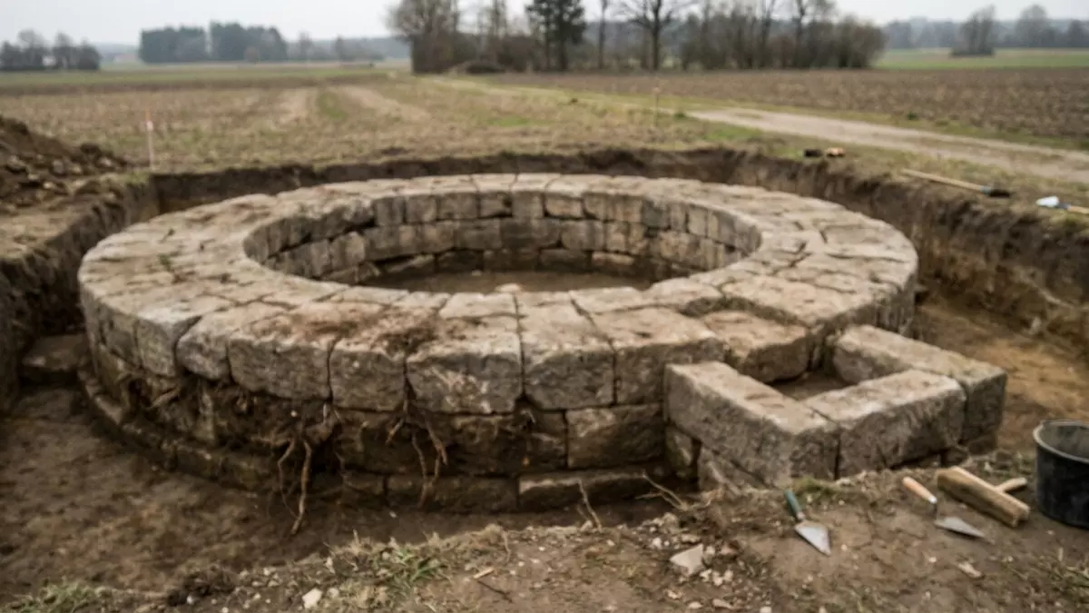
During a routine infrastructure project in Upper Bavaria, construction crews unexpectedly punctured a layer of topsoil to reveal a striking piece of imperial history. Archaeologists called to the scene near the village of Wolkertshofen, close to Nassenfels, have exposed the pristine stone foundations of a monumental, circular Roman structure.
The find, uncovered by teams from the Bavarian State Office for Monument Preservation (BLfD), dates to the Roman Imperial period. Measuring a massive 12 meters in diameter, the precisely engineered stone circle is believed to form the retaining base of a grand, earthen burial mound known as a tumulus. This type of monument served as a towering architectural billboard, built to project the immense wealth, social status, and lasting memory of the region’s provincial elite.
Rare Roman Circular Monument Discovered along Ancient Bavarian Road
A High-Prestige Landmark on the Frontiers of Raetia
The circular monument was strategically placed in antiquity. It sits directly adjacent to a major Roman road that once connected the ancient settlement of Nassenfels to the Altmühl River valley. During the height of the Roman Empire, this road was a vital economic and military artery running through the province of Raetia—an imperial frontier territory that encompassed parts of modern-day southern Germany, Switzerland, and the Austrian Tyrol.
 Seizure of Carthaginian Bronze Coins Highlights Ancient Economy and Illicit Antiquities Trade
+------------------------+----------------------------------------------------+
| Monument Attribute     | Archaeological Discovery Details                   |
+------------------------+----------------------------------------------------+
| Location Discovery     | Wolkertshofen, near Nassenfels, Upper Bavaria       |
| Primary Structure      | Circular stone ring, ~12 meters (39 feet) wide      |
| Attached Annex         | Southern square base measuring 2 by 2 meters       |
| Historical Province    | Raetia (Roman Imperial Period)                      |
| Functional Class       | Cenotaph (Symbolic, empty commemorative tomb)      |
+------------------------+----------------------------------------------------+
In the Roman world, burial alongside major highways was a deliberate strategy. Because cemeteries were legally barred from inside city walls, the wealthy built their tombs along the busiest roads outside town. Every merchant, soldier, and traveler walking the provincial border would be forced to gaze upon the monument, keeping the deceased individual’s name and social prestige alive across generations.
The monument’s proximity to a nearby villa rustica—a sprawling, wealthy Roman agricultural estate—strongly implies that the monument was funded by a prosperous local landowner to honor a prominent member of their family line.
The Wolkertshofen Cenotaph: Engineering a Symbolic Grave
The architectural layout of the Wolkertshofen monument showcases a beautiful blend of precise Mediterranean engineering and regional construction styles. The primary ring consists of tightly fitted stone foundations designed to hold back tons of packed earth that would have formed the original, conical hill of the tumulus.
                     TOP-DOWN ARCHITECTURAL LAYOUT

                         /===############===\
                      /########        ########\
                     |###                    ###|
                     |###     [EMPTY CORE]   ###|  <--- 12-Meter Ring
                     |###    (No Human Bones)###|
                      \########        ########/
                        \===##############===/
                                 ||
                           [SQUARE ANNEX]          <--- 2m x 2m Stone Base
                           (Statue / Stele)
Adding immense intrigue to the structure is a distinct, square stone annex measuring 2 by 2 meters built onto the southern edge of the circle. Excavators suggest that this stone projection served as a heavy structural platform designed to support a tall commemorative marker stone (a stele) or a life-sized stone statue of the individual being honored.
The Mystery of the Empty Core
When archaeologists systematically excavated the interior center of the stone circle, they were surprised to find a complete lack of human skeletal remains, cremated ash urns, or valuable funeral offerings. Because the stone foundations are completely undisturbed and show no signs of historical looting, scientists have concluded that the structure is a cenotaph—an intentional, purely symbolic empty tomb.
In the Roman military and elite classes, individuals frequently died far from home due to sudden battlefield casualties, political postings, or shipping disasters abroad. When a body could not be recovered for a traditional funeral, the family would construct a highly visible cenotaph in their home province. This gave the grieving family a physical, sacred space to perform vital annual remembrance rituals, keeping the spirit of the deceased at peace while broadcasting the family’s regional influence.
Layered History: A Sacred Landscape Across Millennia
The discovery at Wolkertshofen has also revealed that the choice of this specific geographic location was steeped in deep-time tradition. As the archaeological team dug around the Roman foundations, they exposed a multi-layered prehistoric landscape beneath and around the stone monument.
                  CHRONOLOGICAL OCCUPATION TIMELINE

  [Neolithic Era] ===> [Bronze Age] ===> [Iron Age / Celts] ===> [Roman Empire]
  * Early Farmers       * Metal Tool      * Pre-Roman Mounds      * 12m Circular
    Leave Pottery         Settlement        & Cultural Links        Stone Cenotaph
The trenches yielded rich concentrations of ancient pottery shards and residential post-holes pointing to continuous human occupation spanning the Neolithic, Bronze, and Iron Ages.
When Roman-era citizens erected this massive stone circle in the first centuries CE, they were building on ground that had already been deemed culturally or spiritually significant for thousands of years. In many northwestern provinces, incoming Romans deliberately built their new tumuli right next to or directly on top of ancient, pre-Roman Celtic burial mounds to physically and visually link their new imperial authority with the deep, ancestral roots of the local landscape.
Conclusion
The rare stone circle of Wolkertshofen stands as a spectacular example of ancient monumentality and memory preservation on the edge of the Roman world. Though stripped of its earthen mound and any accompanying statues over centuries of agricultural plowing, its heavy foundations remain a powerful testament to the technical skill and social ambitions of Bavaria’s early Roman communities. As scientists continue to process local soil samples and analyze the structural mortar, this empty tomb will continue to fulfill its original purpose: making sure the voices, identities, and histories of the past are never forgotten.
Frequently Asked Questions
What exactly is a Roman tumulus?
A tumulus is a specific type of ancient burial monument consisting of a massive, rounded mound of earth or stone raised over a central grave. In the Roman provinces, these earth mounds were often encircled by a heavy, decorative stone retaining wall to stabilize the dirt and project a high-status architectural appearance.
Why are there no human bones inside the Wolkertshofen monument?
Archaeologists have identified the structure as a cenotaph, which is an intentional symbolic tomb built without a physical body. It was typically constructed by wealthy Roman families when a loved one died far away from home (such as in a distant war or a shipwreck), creating a local monument where family members could perform mandatory funeral rites.
Where is the province of Raetia located?
Raetia was an important frontier province of the Roman Empire. Its historical boundaries covered what is now central and eastern Switzerland, southern Germany (primarily Bavaria and Baden-Württemberg), the Vorarlberg and Tyrol regions of western Austria, and portions of northern Italy.
How did a stormwater project lead to this discovery?
In Germany, strict cultural heritage laws require certified archaeological surveys to be conducted before any major civic construction can begin. While breaking ground for a new stormwater retention basin in the autumn of 2024, survey teams identified the historic stone foundations, halting construction to allow for a meticulous scientific excavation.
What was the purpose of the 2-meter square annex on the side?
The square stone base attached to the southern edge of the circle acted as a reinforced structural foundation. Archaeologists believe it was engineered to support a heavy, vertical stone monument (a stele) inscribed with the name of the deceased, or a customized portrait statue looking out toward the adjacent Roman highway.