Table of Contents
- 1. Engineering the Sacred: The Megalithic Landscape of Murayghat
- 2. Anatomy of the Central Knoll: Altars and Feasting Halls
- 2.1. Evidence of Communal Feasting
- 2.2. A Town with No Homes
- 3. Adapting to Climate and Political Collapse
- 4. Conclusion
- 5. Frequently Asked Questions
- 5.1. What exactly is a dolmen, and how was it used at Murayghat?
- 5.2. How do archaeologists know that people didn’t permanently live at Murayghat?
- 5.3. What caused the collapse of the earlier Chalcolithic culture in Jordan?
- 5.4. Why are the pottery vessels found at the site unusually large?
- 5.5. What does the term “anthropogenic landscape” mean in archaeology?
Ancient Jordanian Ritual Site Rewrites the History of Crisis Adaptation
More than five millennia ago, the communities of the southern Levant were plunged into a period of profound instability. The Chalcolithic culture, which had flourished for centuries with established farming villages and rich artistic traditions, collapsed under the combined weight of severe climate shifts, fragmented political systems, and crumbling international trade routes.
Yet, out of this prehistoric dark age emerged an extraordinary testament to human resilience. Archaeologists from the University of Copenhagen have uncovered a vast, 5,500-year-old ceremonial landscape at a site known as Murayghat in central Jordan. Dating to the Early Bronze Age I (around 3500–3000 BCE), this monumental complex was built not as a town for the living, but as a sprawling sacred center for ritual, remembrance, and social survival.

Ancient Jordanian Ritual Site Rewrites the History of Crisis Adaptation
Engineering the Sacred: The Megalithic Landscape of Murayghat
Situated southwest of the historic city of Madaba, Murayghat is a complex architectural marvel mapped across a series of rugged hills surrounding a prominent central knoll. Rather than building houses or protective fortifications, the ancient people dedicated their collective labor to reshaping the topography itself into what scholars call an “anthropogenic landscape”—a human-built environment heavily saturated with symbolic and spiritual meaning.
+------------------------+----------------------------------------------------+
| Site Feature           | Archaeological Details                             |
+------------------------+----------------------------------------------------+
| Geographic Setting     | Southwest of Madaba, Central Jordan                |
| Chronological Era      | Early Bronze Age I (Approx. 3500–3000 BCE)         |
| Core Infrastructure    | 95+ Megalithic dolmens, standing stones, cairns    |
| Operational Nature     | Non-residential, standalone ceremonial complex     |
+------------------------+----------------------------------------------------+
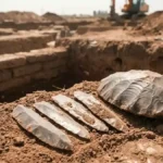
The sheer scale of the construction is breathtaking. Researchers have documented more than 95 dolmens—monumental stone burial chambers constructed from massive slabs of local limestone—climbing the hillsides. These chambers range from two meters long to over four meters in size, with some raised on specially prepared stone platforms.
                       VISUAL LAYOUT OF THE CEREMONIAL SITE

                [Dolmen Cluster]         [Dolmen Cluster]
                       \\                       //
                        \\                     //
                         v                     v
                    +-------------------------------+
                    |         CENTRAL KNOLL         |
                    | * Bedrock with Ritual Cup-Marks|
                    | * Megalithic Double-Faced Walls|
                    +-------------------------------+
                         ^                     ^
                        //                     \\
                       //                       \\
                [Dolmen Cluster]         [Dolmen Cluster]

    * Note: The vast majority of the 95+ dolmens are deliberately
      aligned to directly face the central hill for collective visibility.
The placement of these stone monuments was not random. The vast majority of the dolmens are physically aligned to face the central knoll. This deliberate arrangement ensured that any ritual performed on the hill was completely visible to communities gathered across the landscape, turning the entire valley into a grand theater for collective participation.
Anatomy of the Central Knoll: Altars and Feasting Halls
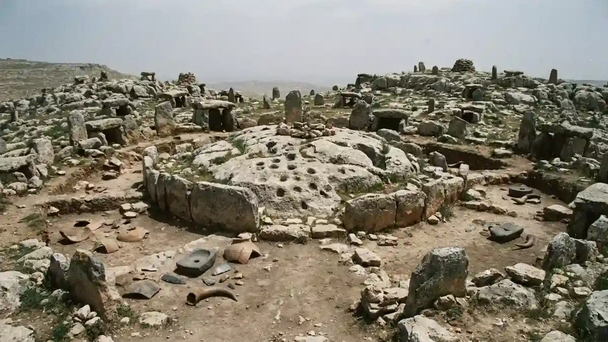
The central knoll served as the literal beating heart of the Murayghat complex. On its crest, archaeologists exposed heavily modified, smoothed bedrock surfaces carved with intricate “cup-marks” and deep rectangular depressions. Because these features show zero signs of domestic utility, they are interpreted as sacred altars designed for libations, symbolic offerings, or ritualistic protocols.
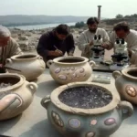
Evidence of Communal Feasting
The artifact profile extracted from the site confirms that Murayghat hosted massive, regional gatherings. Excavators unburied a diverse array of specialized tools and vessels, including:
Massive Pottery Jars: Oversized ceramic vessels capable of holding up to 25 liters of liquid or grain.
Basalt Grinders & Flint Tools: Equipment used to process food and meat on a large scale.
Animal Horn Cores: The physical remnants of livestock brought to the site for sacrifice and consumption.

A Town with No Homes
Crucially, the site features a total absence of residential hearths, permanent roofing structures, domestic trash heaps, or everyday debris. People did not live at Murayghat. Instead, mobile pastoralist groups scattered across the fragmented region would regularly migrate to this sacred landscape, using the space to feast, renew social bonds, and honor their ancestors before dispersing back into the wilderness.
Adapting to Climate and Political Collapse
The deep historical significance of Murayghat lies in its broader political and environmental context. When the central authorities of the preceding Chalcolithic period dissolved, the southern Levant fractured into isolated, politically fragmented groups experiencing intense environmental stress.
                  EVOLUTIONARY RESPONSE TO ACCIDENTS

  [ Environmental / Political Collapse ] ===> Breaks traditional village ties.
  [ Creation of Ritual Landscapes ]      ===> Replaces lost central states.
  [ Monumental Construction (Dolmens) ] ===> Visual anchor to reclaim land rights.
  [ Regional Communal Feasting ]         ===> Forges alliances to survive crises.
In the absence of kings, chiefs, or central cities, the construction of these massive stone monuments became a vital survival strategy. By banding together to move multi-ton limestone blocks, these fragmented communities were actively preventing total social breakdown.
The dolmens and standing stones acted as permanent visual anchors in the landscape. They served as public declarations of land ownership, sacred neutral grounds where rival groups could peacefully negotiate trade alliances, and spiritual sanctuaries where a fractured society could systematically rebuild its collective sense of belonging.
Conclusion
The pioneering research at Murayghat, recently published in the journal Levant, offers a beautiful lesson in how early human societies successfully adapted to catastrophic historic crises. It proves that when structural systems collapse, humanity does not automatically devolve into isolated violence. Instead, the ancient people of Jordan turned to art, monumentality, and monumental architecture to forge unity out of chaos. By leaving their mark on the limestone hills of Madaba, they created an enduring legacy of community strength that continues to speak volumes 5,500 years later.
Frequently Asked Questions
What exactly is a dolmen, and how was it used at Murayghat?
A dolmen is a prehistoric megalithic structure typically consisting of two or more vertical standing stones supporting a large, flat horizontal capstone. While traditionally used as burial chambers across the ancient world, the excavated examples at Murayghat lacked human skeletal remains, suggesting they served a highly symbolic, commemorative, or ritualistic landmark purpose rather than acting as active graves.
How do archaeologists know that people didn’t permanently live at Murayghat?
The site completely lacks the classic signatures of a prehistoric village or domestic settlement. Archaeologists found no residential cooking hearths, zero evidence of permanent roofing or house foundations, and no typical domestic household trash. All recovered items point exclusively to temporary, large-scale ceremonial use and communal feasting.
What caused the collapse of the earlier Chalcolithic culture in Jordan?
The transition away from the Chalcolithic period into the Early Bronze Age was primarily driven by severe regional climate shifts that disrupted agriculture, paired with the sudden breakdown of established long-distance trade routes and local political alliances, resulting in widespread social fragmentation.
Why are the pottery vessels found at the site unusually large?
The excavation team recovered massive storage jars capable of holding up to 25 liters of contents. These oversized vessels were intentionally engineered to store and serve massive amounts of food or drink, providing clear evidence of large-scale communal feasting and shared ritual offerings during regional gatherings.
What does the term “anthropogenic landscape” mean in archaeology?
An anthropogenic landscape refers to a natural geographic area that has been permanently and deliberately altered, reshaped, or marked by human activity to inject it with cultural, political, or spiritual meaning. At Murayghat, this was achieved by populating the natural hills with dozens of stone dolmens, standing stones, and carved bedrock altars.