
Table of Contents
**1,019km Ancient Water System Mapped at Urartian Fortress**
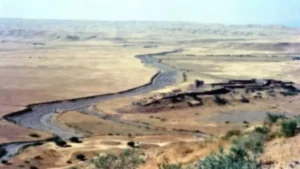
Archaeologists have uncovered an enormous hidden hydraulic network spanning more than 1,000 kilometers around an ancient Urartian fortress in Armenia. This remarkable discovery reveals how one of the ancient Near East’s powerful kingdoms engineered a sophisticated irrigation system that turned a dry plain into thriving farmland over 2,700 years ago.
The massive water-management infrastructure around Argishtikhinili demonstrates the impressive engineering skills of the Urartian civilization. By mapping over 134 kilometers of potential ancient canals alongside modern features, researchers are gaining fresh insights into how Urartu supported large urban centers and agricultural economies in a challenging landscape.
1,019km Ancient Water System Mapped at Urartian Fortress
### The Powerful Kingdom of Urartu and Its Engineering Legacy
The kingdom of Urartu flourished in the 9th to 6th centuries BCE across the South Caucasus, including parts of modern Armenia, eastern Turkey, and northwestern Iran. Often overshadowed by neighboring empires like Assyria, Urartu built impressive fortresses, temples, and cities while developing advanced metallurgical and hydraulic technologies.

Argishtikhinili, founded by King Argishti I between 786 and 764 BCE, served as one of the kingdom’s major political and religious centers. Located near present-day Armavir in Armenia’s Araks Valley, the fortress-city stretched across roughly 3.5 kilometers and featured two citadels positioned on natural rises. Ancient inscriptions proudly describe how the king ordered the construction of five irrigation channels to supply water to urban areas, fields, gardens, and vineyards.
These royal texts emphasize that the area was previously uncultivated due to water scarcity. The new mapping project confirms that large-scale irrigation likely began under Urartian rule, transforming the arid Ararat Plain into a productive agricultural heartland.
### Mapping a Hidden Hydraulic Landscape

A collaborative research team conducted extensive surveys beginning in 2013, combining traditional fieldwork with cutting-edge remote sensing technologies. They analyzed data from multiple sources:
– Landsat 5 satellite imagery
– Sentinel-1 radar data
– Declassified CORONA and GAMBIT spy satellite photographs from the Cold War era
– High-resolution digital elevation models
The older spy satellite images proved particularly valuable, capturing the landscape before intensive modern agriculture altered many features. Using GIS software, researchers processed vegetation patterns, soil color variations, and subtle terrain relief to identify ancient water channels.
The final map reveals an astonishing 1,019.05 kilometers of water-related features. This includes:
– 428.9 km of modern irrigation canals
– 419.6 km of former mountain streams and old river branches
– 36 km of deeply incised palaeochannels
– 134.6 km of suspected ancient canals concentrated around Argishtikhinili
This comprehensive hydraulic system represents one of the largest mapped ancient water networks in the region, highlighting Urartu’s sophisticated approach to water resource management.
### How the Irrigation System Worked
The ancient engineers faced significant challenges. The Araks Valley has low gradients, shifting river courses, and tectonic activity that constantly reshaped the terrain. Despite these difficulties, Urartian planners created straight canal segments and winding levees that effectively distributed water from the Araks River and mountain streams.
Many suspected ancient channels follow northeast orientations, suggesting they connected to dried stream beds or drew water directly from the main river. Some features appear as clear ravine-like cuts in the landscape, while others show up through differences in vegetation growth or soil coloration.
Researchers noted that straight canal segments likely reflect later modifications, while more organic, winding patterns may preserve older Urartian designs. The presence of ancient levees and crevasse splays formed by shifting river branches further illustrates the dynamic relationship between natural water flows and human engineering.
### Life in Argishtikhinili: A Thriving Ancient City
At its peak, Argishtikhinili functioned as a major administrative and religious hub. The dual-citadel design provided both defensive advantages and symbolic power. With reliable irrigation, residents could cultivate wheat, barley, grapes, and other crops while maintaining lush gardens and orchards that supported urban life.
The ability to control water gave Urartian rulers significant political power. Reliable agriculture supported large populations, sustained armies, and strengthened economic control over surrounding territories. This hydraulic infrastructure likely played a crucial role in Urartu’s ability to resist Assyrian expansion and maintain independence for centuries.
After Urartu’s collapse around 590 BCE, the region saw continued occupation through the Hellenistic, medieval, and modern periods. Later societies often reused or modified older canal routes, creating the complex layered landscape visible today.
### Advanced Technology Uncovers Ancient Engineering
The success of this project demonstrates how modern remote sensing is revolutionizing archaeology. Traditional ground surveys would have taken decades to map such an extensive area. By combining multiple satellite datasets with sophisticated processing techniques, researchers could detect faint traces that might otherwise remain invisible.
The use of declassified spy satellite imagery was especially effective because it provided historical baselines before heavy mechanized farming and new irrigation projects obscured older features. This approach offers a model for similar studies in other arid regions where ancient water systems have been overwritten by modern development.
### Challenges in Interpreting the Ancient Landscape
Dating individual canal segments remains difficult. While many features cluster around Argishtikhinili and align with known Urartian activity, some may have been built or expanded during later periods. Future work involving targeted excavations, sediment analysis, and dating methods will help create more precise timelines.
The landscape itself poses additional complications. River migration, earthquakes, and intensive modern agriculture have erased or modified many subtle archaeological traces. Despite these challenges, the Araks Valley preserves an unusually detailed record of long-term water management strategies.
### Why This Discovery Matters for Ancient History
The mapping of this massive hydraulic system positions Argishtikhinili as a prime example of Urartian innovation in water engineering. It demonstrates how ancient states used large-scale infrastructure projects to support urbanization and assert control over fertile territories.
This research also contributes to broader discussions about sustainability and environmental adaptation. The Urartians successfully managed water resources in a semi-arid environment for centuries, offering potential lessons for modern water management in the face of climate challenges.
As one of the lesser-studied civilizations of the ancient Near East, Urartu is finally receiving the attention it deserves. Discoveries like this hydraulic network help restore the kingdom to its proper place in history as a sophisticated society with advanced technological capabilities.
### Future Research Directions
The team emphasizes that more archaeological investigation is needed. Planned excavations near suspected ancient canals could provide dating materials and direct evidence of Urartian construction techniques. Additional remote sensing in surrounding areas may reveal even more extensive water systems connected to other Urartian centers.
Collaborative projects involving Armenian, Polish, and international researchers continue to expand our knowledge of this fascinating kingdom. Each new discovery adds depth to our understanding of how ancient societies engineered their environments to support complex urban life.
**Conclusion**
The revelation of a vast 1,019-kilometer hydraulic system around the Urartian fortress of Argishtikhinili marks a major advancement in our understanding of ancient water management in the South Caucasus. This sophisticated network of canals, levees, and channels shows how Urartian engineers transformed a challenging landscape into a productive agricultural region that supported one of the area’s most important ancient cities.
By combining cutting-edge remote sensing technology with careful analysis, researchers have uncovered traces of human ingenuity that survived for nearly three millennia. The findings not only highlight Urartu’s engineering achievements but also demonstrate the enduring impact of strategic water control on the development of early states.
As further studies refine our knowledge of these ancient systems, Argishtikhinili stands as a powerful testament to the creativity and determination of ancient peoples who shaped their world through remarkable hydraulic engineering. This discovery enriches our appreciation of Armenia’s deep historical heritage while offering valuable perspectives on humanity’s long relationship with water resources.
**FAQ**
**Q: How large is the mapped water system around Argishtikhinili?**
A: Researchers identified over 1,019 kilometers of water-related features, including 134.6 kilometers of possible ancient canals.
**Q: Who built the original irrigation system?**
A: The Urartians, under King Argishti I in the 8th century BCE, are credited with establishing large-scale irrigation in the Araks Valley.
**Q: What technologies were used to map the ancient canals?**
A: The team used Landsat imagery, Sentinel-1 radar, declassified CORONA and GAMBIT spy satellite photos, digital elevation models, and GIS software.
**Q: Why was irrigation so important for Urartu?**
A: The Araks Valley required reliable water management to support agriculture, urban populations, and political control in an otherwise dry environment.
**Q: Are all the mapped canals from the Urartian period?**
A: Not necessarily. While many date to or were influenced by Urartian engineering, some were modified or added in later Hellenistic, medieval, or modern periods.
**Q: Where is Argishtikhinili located?**
A: The ancient fortress lies near present-day Armavir in western Armenia, in the fertile but irrigation-dependent Araks Valley.
**Q: What makes this discovery significant?**
A: It provides some of the clearest evidence yet of large-scale water engineering by the Urartian kingdom and highlights their role in transforming the Armenian landscape.