
Table of Contents
- 1. The Underwater Search That Rewrote Swiss History
- 2. Mapping the Architecture of a Late Roman Crossing
- 3. Solving a Centuries-Old Geographical Puzzle
- 3.1. Why Rome Chose Salodurum
- 3.2. The Hidden Meaning Behind the Name
- 4. A Miraculous Survival Against Modern Development
- 5. Preserving the Ruins for Future Deep-Water Study
- 6. Conclusions
- 6.1. Frequently Asked Questions
Roman Bridge Found in Swiss River Confirms Ancient Highway Route
Archaeologists working along the Aare River have unearthed the physical proof of a long-lost Roman bridge. Located in the modern city of Solothurn, Switzerland, these submerged timber remains confirm a vital river crossing that historians have chased for nearly a century. The structural ruins provide an undeniable link to the ancient settlement of Salodurum, shifting our understanding of how the Roman Empire secured its northern frontiers.
This remarkable underwater discovery brings a legendary transit route into the light, illustrating how ancient engineering shaped regional travel and military strategy during a period of deep imperial transition.
Roman Bridge Found in Swiss River Confirms Ancient Highway Route
The Underwater Search That Rewrote Swiss History
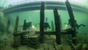
The breakthrough did not happen by chance. It emerged during routine underwater surveys conducted ahead of an upcoming renovation project on a local railway bridge. Anticipating that the riverbed might harbor hidden historical treasures, the cantonal archaeology service deployed a team of specialized divers in early 2025 to scan the area near the modern Wengi Bridge.
Peering through the murky currents of the Aare River, divers spotted several massive wooden piles driven deep into the river sediment. Recognizing the potential significance of the heavily waterlogged timbers, researchers carefully extracted core samples for laboratory analysis.
The results exceeded expectations. Dendrochronological dating placed the wood squarely within the fourth century CE. This timeline links the bridge to the Late Roman period—a chaotic era when the open civilian town of Salodurum was rapidly refortified into a secure military stronghold known as a castrum.

Mapping the Architecture of a Late Roman Crossing
The structural remains offer an intriguing look at Roman frontier engineering. Archaeologists identified a distinct, organized row of heavy wooden piles positioned roughly ten meters from the southern edge of the riverbank. Several of these preserved timbers stretch nearly two meters in length, showcasing the scale of the ancient infrastructure.
+-------------------------------------------------------------+
|               ANCIENT ROMAN BRIDGE DESIGN                   |
+-------------------------------------------------------------+
|                                                             |
|   [ Roadway / Timber Deck ]  <-- For Soldiers & Trade       |
|   =========================                                 |
|         ||           ||                                     |
|         ||           ||      <-- Cross-Bracing Structures   |
|     +-------+     +-------+                                 |
|     | Stone |     | Stone |  <-- Submerged Pier Foundations |
|   :-| Spire |-----| Spire |-:                               |
|  .  +-------+     +-------+  .                              |
| . . . . . . . . . . . . . . . .  <-- Aare River Waterline   |
|                                                             |
|       |||           |||                                     |
|       |||           |||      <-- Heavy Oak Vertical Piles   |
|==== input ===     === input ===                             |
|~~~~~~~~~~~~~~~~~~~~~~~~~~~~~~~   <-- Riverbed Sediment      |
+-------------------------------------------------------------+
The specific alignment and spacing of the posts indicate they served as the load-bearing foundation for a massive bridge pier. These vertical supports were designed to anchor a heavy wooden platform, raising a reliable roadway high above the unpredictable waters of the Aare.
Building a permanent bridge in this territory required immense skill. The builders had to account for seasonal flooding, rapid currents, and the soft, shifting composition of the riverbed floor. The discovery of these deep-set piles proves that Roman engineers successfully overcame these environmental hurdles to maintain their grip on the region.

Solving a Centuries-Old Geographical Puzzle
For generations, academics argued that a major Roman crossing had to exist somewhere near Solothurn, though tangible proof remained elusive. The geographic logic was compelling: Salodurum sat directly along a crucial transport vein connecting the heart of northern Italy to the volatile Rhine frontier.
Travelers and legions marching north would cross the Alps via the Great St. Bernard Pass, journey across the western Swiss Plateau, and navigate the rugged Jura region. The Aare River formed the final major water barrier before travelers reached the outer imperial borders. While researchers had previously mapped out distinct sections of the Roman roadway running through nearby Büren an der Aare and Nennigkofen, the exact point where the road crossed the water remained a missing link until now.
Why Rome Chose Salodurum
The choice of this specific crossing site reveals the strategic eye of Roman military planners. Upstream from the modern city, the Aare River meanders through wide, winding loops that are difficult to bridge securely. However, as the river reaches the historic core of Solothurn, the channel narrows dramatically.
This natural bottleneck offered two distinct advantages to ancient builders:
Shorter Span: The narrow channel required fewer building materials and less construction time to span the water.
Stable Current: A compressed river channel often featured more predictable banks, making it easier to anchor permanent timber and stone foundations.
The Hidden Meaning Behind the Name
Even the linguistic history of the area pointed toward this hidden bridge. The ancient Roman designation Salodurum traces its roots back to an older Celtic place-name. Linguists and historians typically translate this ancient term as “river narrows” or “wave gate.”
For years, this etymology was viewed as a strong textual hint that the area served as a primary hub for water transport and regional travel. The physical discovery of the fourth-century timbers finally transforms this long-held geographical theory into an undeniable historical fact.
A Miraculous Survival Against Modern Development
The fact that these ancient timbers survived to the present day is nothing short of a miracle. In 1969, the river system around Solothurn underwent massive civil engineering modifications. Large stretches of the Aare riverbed were systematically dredged, scraped, and deepened to improve regional water management and navigation.
During those aggressive operations, delicate wooden artifacts and ancient structures across the region were wiped away. Fortunately, the fourth-century bridge piles were located directly beneath the footprint of the Wengi Bridge. The modern bridge supports acted as an unintentional protective shield, blocking the heavy dredging equipment from reaching and destroying the priceless Roman timbers underneath.
Preserving the Ruins for Future Deep-Water Study
Local officials emphasize that the current railway bridge construction poses no danger to the newly found archaeological site. Instead of pulling the timbers out of the riverbed for museum display, the cantonal archaeology service plans to leave the structures exactly where they were found.
Leaving ancient wood underwater is a widely accepted preservation strategy. The oxygen-poor, waterlogged environment of the riverbed slows down organic decay, protecting the wood from cellular breakdown far better than exposure to open air. Moving forward, dive teams will continue conducting targeted underwater campaigns to map the remaining sections of the platform, giving us a clearer look at the total scale of this ancient architectural feat.
Conclusions
The unearthing of the Roman bridge at Salodurum closes a significant gap in our understanding of Europe’s classical past. By turning circumstantial geographic clues, ancient place-names, and fragmented road networks into tangible proof, archaeologists have verified a crucial link in the Roman Empire’s transit system. This submerged monument stands as a lasting reminder of the engineering brilliance that unified the ancient Western world.
Frequently Asked Questions
How old is the Roman bridge found in Solothurn?
Laboratory analysis and wood-dating techniques place the construction of the bridge foundations in the fourth century CE, making the structure approximately 1,700 years old.
Why is the location of the bridge historically significant?
The discovery provides the first physical proof of a major river crossing along a vital imperial highway. This route allowed Roman legions and merchants to travel efficiently from northern Italy through the Alps directly to the critical Rhine frontier.
What does the ancient name “Salodurum” mean?
The name Salodurum is derived from an early Celtic phrase translated as “river narrows” or “wave gate.” It highlights the natural bottleneck along the Aare River that made the location perfect for building a bridge.
How did the wooden piles survive modern river dredging?
During extensive river engineering and dredging projects in 1969, the ancient timbers were protected by the physical footprint of the modern Wengi Bridge, which prevented heavy machinery from disturbing the riverbed directly beneath it.
Why are archaeologists leaving the ancient wood underwater?
Waterlogged, low-oxygen environments naturally protect ancient wood from rapid decay and bacterial breakdown. Keeping the timbers submerged preserves the structural integrity of the artifacts while allowing dive teams to study them safely in place.