
**5,000-Year-Old Scottish Crannog Predates Stonehenge**
Archaeologists have revealed astonishing new details about a 5,000-year-old artificial island submerged in a Scottish loch, proving that sophisticated Neolithic engineering thrived in Britain centuries before the construction of Stonehenge. This ancient crannog on the Isle of Lewis showcases the remarkable ingenuity of early communities who shaped their watery landscapes for living, gathering, and ritual activities.
The discovery not only pushes back the timeline of these iconic Scottish structures but also introduces innovative survey techniques that could transform how researchers explore similar hidden sites across the globe.
5,000-Year-Old Scottish Crannog Predates Stonehenge

### Uncovering an Ancient Engineering Marvel in Loch Bhorgastail
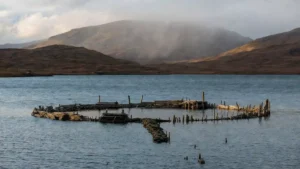
Nestled in the waters of Loch Bhorgastail on Scotland’s Isle of Lewis, what appears today as a modest stone island was once a carefully engineered timber platform built during the Neolithic period. Researchers from the University of Southampton, collaborating with experts from the University of Reading, conducted detailed excavations and underwater surveys that uncovered this early crannog.
Crannogs—small artificial islands constructed in lakes and lochs—have traditionally been associated with the Iron Age. However, mounting evidence shows some examples date much earlier, between 3800 and 3300 BCE. The Loch Bhorgastail site ranks among the oldest known, predating Stonehenge by several hundred years and offering fresh insights into prehistoric life in northern Britain.

The initial structure was a circular wooden platform measuring approximately 23 meters (75 feet) across. Builders layered timber and brushwood to create a stable foundation in the shallow waters. This ambitious project required significant coordination, raw materials, and labor, pointing to well-organized Neolithic societies capable of large-scale construction.
### Multiple Phases of Use Across Millennia
The crannog was not a one-time build but evolved over thousands of years. Around 2,000 years after its initial construction, during the Middle Bronze Age, people added more brushwood layers and capped sections with stone. Another major phase occurred in the Iron Age roughly 1,000 years later, showing the site’s enduring importance to local communities.
 Radiocarbon dating confirms Teutonic Knights built Feldioara Fortress in 13th-century Transylvania
A submerged stone causeway connecting the island to the mainland further highlights its accessibility in ancient times. Changes in water levels over the centuries have since altered the landscape, partially submerging features that were once easier to reach.
These repeated building episodes suggest the crannog served as a long-term hub for social, economic, and possibly ceremonial activities. Its location in a loch provided natural defense while allowing control over fishing, travel routes, and surrounding resources.
### Neolithic Pottery and Evidence of Communal Feasting
Underwater surveys around the island recovered hundreds of pottery fragments from the Neolithic era. These included pieces of jars and bowls, some still containing traces of ancient food residues. Such finds indicate repeated gatherings involving food preparation and communal meals.
The sheer volume of material points to the crannog functioning as a social gathering place rather than a simple dwelling. Families or larger groups likely came together for feasts, rituals, or seasonal celebrations, strengthening community bonds in the challenging northern environment.
The effort required to construct and maintain the artificial island reflects societies with surplus resources, skilled labor, and shared knowledge. In the Neolithic period, as farming spread across Britain, such sites may have symbolized status, safety, or spiritual connections to water.
### Revolutionary Survey Methods for Shallow-Water Archaeology
One of the most significant aspects of this research lies in the innovative techniques developed to study the site. Traditional archaeological tools often fail in the tricky “white ribbon” zone—the shallow interface between land and water, typically less than one meter deep. Standard land surveys and marine equipment struggle here, creating gaps in data.
To overcome this, the team pioneered a workflow using stereophotogrammetry tailored for extreme shallow waters. They mounted two waterproof cameras on a fixed frame and had a diver systematically capture overlapping images while maintaining precise positioning. This was combined with aerial drone surveys above the waterline.
Ground control points, scale bars, and high-accuracy RTK-GNSS positioning allowed seamless integration of land and underwater data into unified 3D models. The resulting digital reconstructions, elevation maps, and detailed images achieved accuracy comparable to terrestrial drone surveys—all while remaining portable and cost-effective.
**Challenges Addressed by the New Method:**
– Turbid water and suspended sediments
– Dense underwater vegetation
– Surface glare and light distortion
– Difficult transitions across the waterline
This approach successfully documented both the visible stone elements and hidden timber structures, creating comprehensive records that would have been impossible with conventional methods.
### Broader Impact on Crannog Research in Scotland
Scotland is home to hundreds of crannogs, many still unexplored. While most attention has focused on later Iron Age examples, discoveries like Loch Bhorgastail demonstrate that the tradition began much earlier in the Neolithic. This shifts our understanding of when and why these structures were built.
Early crannogs may have played key roles during the transition to agriculture, helping communities manage resources, store goods, or perform rituals in liminal water settings. Water held deep symbolic meaning in prehistoric Britain, often linked to offerings, boundaries, and the afterlife.
The Isle of Lewis, with its rich archaeological heritage including the famous Callanish Stones, continues to reveal surprises about Neolithic Scotland. The crannog adds another layer to this story, showing how people engineered their environment in creative ways.
### Technological Advances Opening New Doors in Archaeology
The photogrammetry workflow developed for Loch Bhorgastail has applications far beyond Scotland. Many archaeological sites worldwide sit at land-water boundaries—coastal settlements, lake villages, and riverine locations—where data collection has historically been problematic.
By providing a reliable, repeatable method for shallow-water documentation, researchers can now fill critical gaps in the record. This is especially valuable as climate change and rising water levels threaten to submerge or erode more heritage sites.
The technique’s relatively low cost and portability make it accessible for teams working in remote or resource-limited areas. Future projects could apply similar integrated surveys to other Scottish lochs or international sites with comparable challenges.
### What the Find Reveals About Neolithic Society
The Loch Bhorgastail crannog highlights the sophistication of Neolithic communities in Scotland. Building a stable platform in water demanded knowledge of timber selection, structural engineering, and environmental conditions. Transporting materials and coordinating labor suggests hierarchical or cooperative social structures.
Pottery evidence of food consumption points to shared cultural practices. Residue analysis could reveal details about ancient diets, including cultivated plants, wild resources, and cooking methods.
This site also emphasizes the importance of underwater and intertidal archaeology. Many clues to our past lie partially submerged, preserved by water but difficult to access without specialized tools.
### Preservation and Future Research Potential
The shallow waters of Loch Bhorgastail have protected organic materials like wood and brushwood that typically decay on land. Combined with the new survey methods, this creates exciting opportunities for further investigation. Future work might include targeted sampling of sediments or organic remains to extract ancient DNA or environmental data.
With hundreds of unstudied crannogs across Scotland, applying these techniques could uncover a more complete picture of prehistoric settlement patterns, trade networks, and cultural development.
### Conclusion: Rewriting the Story of Ancient Scottish Innovation
The 5,000-year-old artificial island in Loch Bhorgastail stands as powerful evidence of early engineering brilliance in Neolithic Scotland. Far older than Stonehenge, this crannog demonstrates that communities were already mastering complex construction in watery environments thousands of years ago.
Beyond the site itself, the innovative photogrammetry methods developed during the project represent a major leap forward for archaeology. They enable researchers to explore previously inaccessible zones and preserve detailed records of fragile heritage.
As investigations continue, the Loch Bhorgastail crannog will deepen our appreciation for the resilience, creativity, and social organization of Britain’s first farmers. It reminds us that the past often hides in unexpected places—beneath still waters, waiting for modern technology and dedicated archaeologists to bring it back to light.
This discovery enriches Scotland’s prehistoric narrative and inspires renewed interest in how ancient people shaped—and were shaped by—their landscapes. The story of these early island builders continues to unfold, offering timeless lessons about human adaptability and ingenuity.
### FAQ: Questions About the 5,000-Year-Old Scottish Crannog
**How old is the Loch Bhorgastail crannog and how does it compare to Stonehenge?**
The crannog dates to around 3800–3300 BCE, making it approximately 5,000 years old and several centuries older than Stonehenge, which was constructed starting around 3000 BCE.
**What is a crannog and why were they built?**
A crannog is an artificial island built in a loch using timber, brushwood, and stone. They likely served as homes, defensive sites, gathering places, or ritual locations, offering protection and resource access.
**What new technology was used to study the site?**
Researchers developed a specialized stereophotogrammetry system with underwater cameras, combined with drone surveys, to create detailed 3D models across the challenging shallow-water zone.
**What evidence shows communal activities at the crannog?**
Hundreds of Neolithic pottery fragments, including vessels with food residues, suggest repeated cooking, feasting, and social gatherings over many generations.
**Will this discovery change our understanding of Scottish prehistory?**
Yes. It confirms that crannogs began in the Neolithic period much earlier than previously thought and highlights advanced engineering skills among early farming communities in Scotland.
**Can the new survey methods be used at other sites?**
Absolutely. The portable, cost-effective photogrammetry workflow is ideal for documenting other shallow-water archaeological sites worldwide, helping fill data gaps at land-water boundaries.