Table of Contents
- 1. The Lost Infrastructure: Engineering the Citadel’s Water Supply
- 1.1. The Human and Animal Elements of Water Management
- 2. Links to Sultan al-Nasir Muhammad and the Royal Stables
- 3. Sacred Spaces: The al-Hattaba Mosque and Ancient Burials
- 3.1. A Multi-Layered Islamic Cemetery
- 4. High-Tech Documentation and Daily Life Artifacts
- 5. Training the Next Generation
- 6. Frequently Asked Questions
- 6.1. 1. What is the historical significance of the newly discovered water system?
- 6.2. 2. Who built these water management facilities?
- 6.3. 3. What architectural features of the Mamluk mosque were found?
- 6.4. 4. What kinds of artifacts were found inside the wells and surrounding structures?
- 6.5. 5. What do the nearby burial sites tell us about the area’s history?
Mamluk Infrastructure Uncovered: Medieval Water System and Mosque Discovered Near Cairo’s Citadel
A joint archaeological mission outside Cairo’s iconic Saladin Citadel has brought to light the sophisticated engineering and religious life of medieval Egypt. Excavations have revealed a massive, previously unrecorded Mamluk-era hydraulic system alongside the ruins of a historic mosque, filling a major blind spot in the architectural history of Islamic Cairo.
The discoveries were made by a collaborative Egyptian-French team spearheaded by the Supreme Council of Antiquities and the French Institute for Oriental Archaeology (IFAO). The ongoing research focuses on two historic neighborhoods bordering the fortress: Arab al-Yasar and al-Hattaba. This initiative is part of a broader urban conservation and documentation effort aimed at preserving the rich heritage surrounding the medieval citadel.
Mamluk Infrastructure Uncovered Medieval Water System and Mosque Discovered Near Cairo’s Citadel
The Lost Infrastructure: Engineering the Citadel’s Water Supply
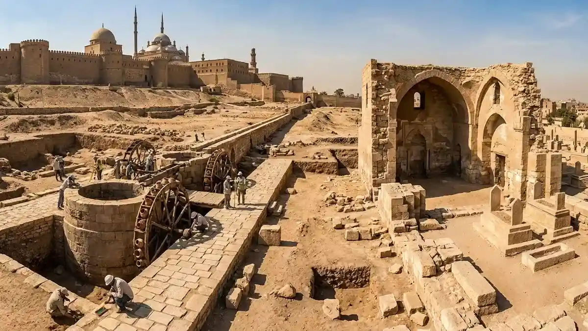
For centuries, historians have marveled at the scale of Cairo’s medieval aqueducts, yet the exact mechanism for delivering water into the elevated Saladin Citadel remained a mystery. The excavations in the Arab al-Yasar district have finally provided the missing link, exposing a complete, highly integrated hydraulic complex.
At the heart of this network sit two monumental wells carved from massive stone blocks. The larger of the two plunges approximately 10 meters into the earth, while the secondary well reaches a depth of about 8 meters. Archaeologists are actively digging further into both structures to locate and clear the original subterranean storage reservoirs.
This complex was engineered specifically to defy gravity, moving massive quantities of water uphill to the fortress. The sophisticated network relied on several interconnected components:
Four Animal-Powered Waterwheels: Heavy mechanical wheels used to lift water out of the deep stone wells.
Stone Aqueduct Channels: A series of raised conduits that directed the lifted water across the terrain.
Direct Aqueduct Connection: The newly exposed structures link directly into Cairo’s famous Sur Magra al-Oyoun aqueduct system, which transported water from the Nile across the city.

The Human and Animal Elements of Water Management
What makes this discovery uniquely valuable to historians is the preservation of the daily operational infrastructure. The team uncovered the complete logistics hub behind the water network, including stone-paved paths trodden by the draft animals that turned the waterwheels, dedicated stables, fodder storage rooms, and animal watering basins. Because historical records completely omit this final, critical leg of the aqueduct system, these physical remains offer the very first look at how water was successfully forced up into the citadel.
Links to Sultan al-Nasir Muhammad and the Royal Stables
Preliminary analysis dates several major sections of the hydraulic hub to the aggressive building campaigns of Sultan al-Nasir Muhammad ibn Qalawun, a fourteenth-century Mamluk ruler renowned for his massive public works and architectural patronage.
During the current excavation season, the team also mapped a previously unknown stone water channel branching off to the west. Archaeologists believe this specific branch was constructed to supply the citadel’s legendary royal stables. This newfound architectural connection is expected to help researchers refine the timeline and construction dates of several surrounding medieval structures.
Sacred Spaces: The al-Hattaba Mosque and Ancient Burials
Simultaneously, excavations in the neighboring al-Hattaba district shifted the focus from civic engineering to religious and communal life. Here, the team unearthed the architectural footprint of a Mamluk-era mosque.
The excavation successfully cleared the mosque’s qibla iwan (the vaulted hall facing Mecca), its mihrab (prayer niche), elements of the southwestern arcade, and large portions of the original stone paving.
A Multi-Layered Islamic Cemetery
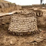
Directly adjacent to the mosque complex, the mission discovered a highly active burial ground spanning multiple centuries of Islamic rule. Several graves and an intact burial chamber yielded human skeletal remains that are now undergoing anthropological analysis. Notably, at least one of the uncovered tombs dates back to the early Islamic period, proving that these neighborhoods were deeply integrated into Cairo’s spiritual and funerary geography long before the Mamluk sultans fortified the area.
High-Tech Documentation and Daily Life Artifacts
The Egyptian-French mission is combining traditional dirt archaeology with advanced digital preservation techniques. Experts are creating highly accurate 3D models of the local monuments, including the Khanqah al-Nizamiyya (a medieval Sufi monastery complex), where fresh architectural features were exposed. A comprehensive digital database is also being built to house all excavation records, architectural drafts, and historical data relating to the citadel’s perimeter.
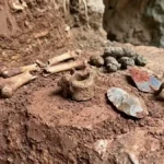
The site has also surrendered an immense collection of small artifacts that paint a vivid picture of centuries of daily life:
Ceramic Waterwheel Buckets: The original clay vessels (qawadis) that were attached to the wooden waterwheels to scoop up well water.
Currency and Seals: Numismatic finds including coins from both the Mamluk and Ottoman periods, along with official metal stamps and personal jewelry.
Modern Material Culture: Household items, everyday tools, and weapon fragments dating to the eighteenth and nineteenth centuries, mapping the continuous occupation of the site into the modern era.
Training the Next Generation
Beyond the historical windfalls, the site serves an essential educational purpose. The project operates as an active field school for Egyptian inspectors of Islamic antiquities. Under the guidance of international experts, local archaeologists receive advanced hands-on training in modern stratigraphic excavation, architectural surveying, professional photography, and spatial digital documentation.
Ultimately, these discoveries prove that significant portions of Cairo’s medieval past still sit perfectly preserved beneath the bustling, historic neighborhoods that flank the Saladin Citadel.
Frequently Asked Questions
1. What is the historical significance of the newly discovered water system?
The discovery is highly significant because it reveals the missing link in Cairo’s medieval infrastructure. While the main Sur Magra al-Oyoun aqueduct was well-known, historical texts never described how water reached the elevated Saladin Citadel. This excavation exposes the exact hydraulic engineering—the wells, wheels, and channels—used to pump water uphill into the fortress.
2. Who built these water management facilities?
Initial architectural and historical studies indicate that major components of the water system were constructed during the reign of the Mamluk Sultan al-Nasir Muhammad ibn Qalawun, who ruled in the fourteenth century and was famous for transforming Cairo’s infrastructure.
3. What architectural features of the Mamluk mosque were found?
Archaeologists in the al-Hattaba district successfully uncovered the mosque’s qibla iwan (the main prayer hall), the mihrab (the niche indicating the direction of Mecca), sections of the southwestern arcade, and the original stone floors.
4. What kinds of artifacts were found inside the wells and surrounding structures?
The team found original ceramic buckets used by the waterwheels to lift water, Mamluk and Ottoman-era coins, jewelry, official metal seals, and everyday domestic items. They also recovered weapon fragments dating to the eighteenth and nineteenth centuries.
5. What do the nearby burial sites tell us about the area’s history?
The presence of graves from various Islamic eras, including one tomb tracing back to the early Islamic period, proves that the land surrounding the citadel was used for sacred and funerary purposes for centuries before the Mamluk water system and mosque were even built.