
Table of Contents
- 1. A High-Stakes Archaeological Rescue Mission
- 2. Dating the Prints: The Late Iron Age Landscape
- 3. Who Walked Lunan Bay 2,000 Years Ago?
- 4. A Uniquely Rare Discovery for Scotland
- 5. Using the Past to Predict Future Coastal Erosion
- 6. Frequently Asked Questions
- 6.1. How do footprints manage to turn into stone or harden over centuries?
- 6.2. Why did the footprints disappear so quickly after being found?
- 6.3. Who were the people living in Scotland during this period of the Iron Age?
- 6.4. What is samphire, and why would ancient people gather it?
- 6.5. Can tourists go to Lunan Bay to see the footprints today?
Ancient Storms Uncover 2,000-Year-Old Footprints on Scottish Beach
A fierce winter storm along the rugged eastern coastline of Scotland has unlocked a fleeting window into the deep past. Powerful waves and high winds stripped away massive layers of sand dunes at Lunan Bay, near Montrose, temporarily exposing an ancient bed of hardened clay. Preserved within this mud were the remarkably clear footprints of prehistoric humans and wild animals who walked across the shoreline two millennia ago.
The rare site was discovered by chance in late January by local residents Jenny Snedden and Ivor Campbell while walking their dogs. Recognizing the historical significance of the clear, deep impressions pressed into the mud, Campbell contacted Aberdeenshire Council’s regional archaeologist, Bruce Mann. What followed was a high-stakes, race-against-the-clock rescue excavation to document the site before the North Sea reclaimed it forever..
Ancient Storms Uncover 2,000-Year-Old Footprints on Scottish Beach
A High-Stakes Archaeological Rescue Mission
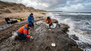
Upon receiving the alert, an expert archaeological team from the University of Aberdeen mobilized immediately. Time was their greatest enemy. The very same coastal forces that exposed the ancient clay layer were already working to destroy it.

The recovery team faced brutal winter conditions, with wind gusts screaming across the bay at over 55 miles per hour. Blowing sand threatened to fill the impressions, while rising tides tore chunks of clay away with every breaking wave. Led by Professor Kate Britton, the archaeologists worked frantically between high tides to document the site.
[48-Hour Race Against Time]
Day 1: Storm strips sand -> Walkers spot prints -> Archeologists arrive
Day 2: 55 mph winds -> 3D laser mapping -> Drone flyovers -> Plaster casting
Day 3: Rising tides erode clay -> Site entirely washed away
Operating under extreme time pressure, the team cleaned sections of the muddy shelf, mapped the exact coordinates of each print, and utilized drones to capture ultra-high-resolution aerial photography. These images allowed scientists to construct millimeter-accurate 3D digital models of the trackways. Before the final high tide dissolved the clay bed completely, the team managed to pour physical plaster casts of the most distinct prints. Within 48 hours of discovery, the entire prehistoric surface had vanished back into the sea.
Dating the Prints: The Late Iron Age Landscape
Back in the safety of the laboratory, researchers processed organic plant matter trapped in the sediment layers directly beneath the trackways. Radiocarbon dating placed the activity precisely around 2,000 years ago.

This date places the footprints squarely within the late Iron Age. Historically, this was a tumultuous and transformative period for ancient Britain, marked by the northern expansion of the Roman Empire and the centuries leading up to the formation of the historical Pictish kingdoms in eastern Scotland.
+-------------------------------------------------------------+
|               SCOTTISH COASTAL TIMELINE                     |
+----------------------+--------------------------------------+
| Era                  | Historical Context                   |
+----------------------+--------------------------------------+
| Pre-Iron Age         | Formation of estuarine clay beds     |
| Late Iron Age        | Humans & deer leave tracks (Tx Site) |
| Romano-British Era   | Roman military push into Scotland    |
| Early Medieval       | Rise of the Pictish Kingdoms         |
| Modern Era           | Storm uncovers & destroys site       |
+----------------------+--------------------------------------+
Two thousand years ago, the geography of Lunan Bay looked vastly different than the wide, sandy tourist beach visitors see today. The geological data indicates the area was once a sheltered, muddy estuary or salt marsh. This nutrient-rich wetland would have been thick with coastal vegetation, serving as a primary feeding ground for local wildlife and a valuable foraging zone for human populations.
Who Walked Lunan Bay 2,000 Years Ago?
An analysis of the shape, depth, and spacing of the preserved tracks revealed a bustling ecosystem where humans and wild animals crossed paths in the mud. The research team identified several distinct categories of prints:

Barefoot Humans: The size and stride measurements of the human footprints suggest that a mixed group of adults and younger individuals traveled across the wet marshland together.
Red Deer & Roe Deer: Deeply imprinted cloven hooves show that large herds of deer regularly frequented the estuary to graze on salt-tolerant marsh plants.
Other Wildlife: Smaller, varied animal tracks crisscrossed the area, indicating a highly active coastal habitat.
Archaeologists believe the prehistoric humans were likely exploiting the natural bounty of the estuary. The group may have descended into the mudflats to hunt the grazing deer, catch fish trapped in tidal channels, or gather valuable coastal plants like samphire, which thrived in ancient Scottish salt marshes.
A Uniquely Rare Discovery for Scotland
While ancient footprint surfaces have occasionally been recorded in other parts of the United Kingdom—most notably at the Severn Estuary in Wales, Formby in Merseyside, and the famous ultra-ancient trails at Happisburgh in Norfolk—this discovery marks the first time a prehistoric footprint site of this nature has ever been documented in Scotland.
“Without the sharp eyes and immediate phone call from the local dog walkers, this priceless window into Iron Age life would have been lost to the sea without ever being recorded.”
— Bruce Mann, Regional Archaeologist
The find provides undeniable, direct physical evidence of human and animal co-existence along the Angus coastline during the Iron Age. It also offers a stark visual lesson in just how rapidly coastal landscapes evolve over geographic time.
Using the Past to Predict Future Coastal Erosion
Beyond its immense historical value, the rescue mission at Lunan Bay is providing vital data for modern environmental science. The high-resolution drone imagery captured during the emergency excavation is now being utilized as an environmental baseline. Climate scientists plan to use these detailed maps to measure and monitor the ongoing rate of coastal erosion within the Montrose basin area.
As rising sea levels and increasingly severe winter storms continue to batter Scotland’s eastern shore, the landscape is shifting faster than ever. Geological surveys suggest that similar ancient clay deposits remain buried beneath neighboring sand dunes. If future storms expose these hidden layers, archaeologists now know exactly what to look for, hoping to catch another brief glimpse of the ancient people who walked this coast two millennia ago.
Frequently Asked Questions
How do footprints manage to turn into stone or harden over centuries?
Footprints are preserved when an animal or human steps into soft, malleable mud or clay that is quickly covered by a protective layer of sediment, such as windblown sand or silt from a high tide. This seals the print away from oxygen and erosion. Over centuries, the weight of the overlying layers compresses the mud into a hardened, semi-rock state, preserving the impression.
Why did the footprints disappear so quickly after being found?
The footprints were preserved in a layer of ancient clay that had been buried securely under deep sand dunes for thousands of years. Once the storm stripped the protective sand away, the fragile clay was directly exposed to the pounding action of the modern ocean waves and heavy winds, causing the soft mud to erode and dissolve within just 48 hours.
Who were the people living in Scotland during this period of the Iron Age?
Around 2,000 years ago, Scotland was inhabited by various Celtic tribal groups. This period coincided with Roman attempts to conquer northern Britain. The Romans referred to the tribal peoples of eastern and northern Scotland as the Caledonii. Centuries later, these distinct tribal groups would coalesce into the historical peoples known as the Picts.
What is samphire, and why would ancient people gather it?
Samphire is a crisp, salty succulent plant that grows naturally in coastal areas, salt marshes, and estuaries. It is highly nutritious and has been gathered by coastal human populations for thousands of years as a valuable source of vitamins and minerals in minerals-poor winter seasons.
Can tourists go to Lunan Bay to see the footprints today?
No, the footprints are no longer visible. The specific clay shelf that contained the impressions was entirely destroyed and washed out to sea by the tides within two days of its exposure. However, the digital 3D models and plaster casts created by the University of Aberdeen have permanently preserved the data for future study and museum display.