
Table of Contents
- 1. Mapping Gawroniec Hill: A Landscape Sculpted by Human Hands
- 2. Discovering the Lost 100-Meter Defensive Trench
- 3. An Industrial Super-Hub Free of Domestic Houses
- 4. Feeding the Ancient European Striped Flint Network
- 5. The UNESCO Connection and the Race Against Erosion
- 6. Frequently Asked Questions
- 6.1. What makes the recent discovery at Gawroniec Hill so important?
- 6.2. What was the primary purpose of the Gawroniec Hill site?
- 6.3. What is striped flint, and why was it so valuable?
- 6.4. How does Gawroniec Hill connect to the UNESCO World Heritage site of Krzemionki?
- 6.5. What threats do the archaeological remains on the hill currently face?
Advanced LiDAR Mapping Reveals Massive Prehistoric Industrial Fortress in Poland
A high-tech archaeological survey on Gawroniec Hill in south-central Poland has uncovered an extraordinarily dense prehistoric industrial complex, completely rewriting what we know about Stone Age manufacturing and defense networks. Utilizing advanced airborne laser scanning and magnetic imaging, researchers identified several thousand distinct traces of ancient human activity, including a massive, hidden defensive ditch that protected a sprawling Neolithic flint-processing hub.
Advanced LiDAR Mapping Reveals Massive Prehistoric Industrial Fortress in Poland
Mapping Gawroniec Hill: A Landscape Sculpted by Human Hands
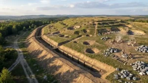
Gawroniec Hill is situated near the municipality of Ćmielów within the Świętokrzyskie Voivodeship, a region globally renowned for its prehistoric geology. The recent investigative project brought together experts from the Historical and Archaeological Museum in Ostrowiec Świętokrzyski and the Relicta Foundation to survey a massive 7.5-hectare territory.
To look beneath the modern topsoil and agricultural interference without digging up the landscape, the team deployed LiDAR (Light Detection and Ranging) airborne laser scanning alongside ground-based magnetic surveys. The resulting digital terrain models revealed that the hill’s topography is not natural; rather, it was entirely reshaped over millennia by intensive human modification, featuring a complex grid of geometric terraces, artificial depressions, and sharp quarrying cuts.

At the base of the hill, archaeologists spotted distinct extraction zones where ancient workers systematically quarried out clay and building stone for local construction. Higher up on the slopes and plateau, the data revealed an incredibly dense pattern of archaeological remains, with some zones reaching nearly 100 industrial features per hectare.
Discovering the Lost 100-Meter Defensive Trench
The most unexpected discovery occurred along the southwestern flank of the hill. The magnetic survey data exposed massive, elongated subterranean anomalies extending continuously for nearly 100 meters and measuring up to five meters in width.
+-------------------------------------------------------------------------+
|                    GAWRONIEC HILL DEFENSIVE DITCH                       |
+------------------------------------+------------------------------------+
| Structural Metric                  | Strategic Function                 |
+------------------------------------+------------------------------------+
| Total Length: ~100 meters          | Positioned at easiest access point |
| Total Width: Up to 5 meters        | Controls entry to the plateau      |
| Design: Deep fortifications        | Protects high-value flint factory  |
+------------------------------------+------------------------------------+
The shape, size, and strategic placement of this earthwork match the exact footprint of a major Neolithic defensive ditch. By fortifying the most vulnerable, easily accessible ridge leading onto the plateau, the ancient builders created a secure bottleneck. This defensive line allowed them to tightly control movement into the settlement during eras of heightened geopolitical tension or peak manufacturing activity.

An Industrial Super-Hub Free of Domestic Houses
Despite decades of sporadic excavations and the precision of the new geophysical imagery, researchers have noted a fascinating anomaly: the site is completely devoid of clear residential house plans.
Traditional Neolithic settlements typically feature post-holes and outlines of domestic longhouses. At Gawroniec Hill, however, the thousands of documented pits are strictly industrial and functional. The site did not operate as a standard village; instead, it was a highly specialized, hyper-focused industrial factory floor.
Raw stone was continually hauled up the hill, organized into specialized processing sectors, and knapped into high-quality survival tools by generations of dedicated artisans.

Feeding the Ancient European Striped Flint Network
During the late Neolithic period (approximately 5,000 years ago), Gawroniec Hill served as a vital, centralized processing node within a massive regional economic network. The site was intimately linked to the world-famous striped flint mines of Świeciechów and Krzemionki.
The raw, unrefined striped flint—celebrated for its distinctive, wavy zebra-like bands—was extracted from the deep subterranean mine shafts nearby and brought directly to Gawroniec Hill. There, workers transformed the rough stones into highly prized polished axes, adzes, and specialized tools.
Once finished, these elite items were exported through robust trade networks across Lesser Poland. The immense geographic reach of this ancient economy is proven by the fact that finished striped flint tools originating from this specific Polish mining complex have been recovered at archaeological sites located up to 660 kilometers away across Europe.
The UNESCO Connection and the Race Against Erosion
Gawroniec Hill forms an irreplaceable part of the wider cultural landscape tied to the Krzemionki Prehistoric Striped Flint Mining Region, which was officially inducted into the UNESCO World Heritage List in 2019. This vast, protected complex represents Poland’s only purely archaeological entry on the prestigious global list.
First officially recorded in 1922, the neighboring Krzemionki complex contains over 4,000 ancient mining shafts that plunge up to nine meters underground. Ancient miners utilized advanced chamber mining methods, cutting through solid limestone with antler picks to extract the precious stone.
However, comparing modern digital terrain models with historical datasets collected since 2010 has revealed a troubling trend: Gawroniec Hill is suffering from steady, aggressive surface loss. The dual forces of natural weather erosion and modern tractor farming are gradually scraping away and flattening the shallow, unexcavated industrial pits near the surface.
In light of these findings, researchers are calling for an immediate, aggressive conservation plan tailored specifically to protecting these vulnerable above-ground processing settlements, ensuring that the critical industrial context surrounding the famous underground mines is preserved for future generations.
Frequently Asked Questions
What makes the recent discovery at Gawroniec Hill so important?
The survey used advanced LiDAR and magnetic mapping to reveal an extraordinarily dense prehistoric industrial complex and a previously unknown 100-meter-long defensive ditch, proving the site was a heavily fortified, specialized manufacturing hub.
What was the primary purpose of the Gawroniec Hill site?
Unlike typical Stone Age villages, Gawroniec Hill lacked domestic house structures. Instead, it operated as a centralized, high-density industrial factory dedicated to processing raw striped flint into polished tools and weapons.
What is striped flint, and why was it so valuable?
Striped flint is a rare, highly durable variety of flint characterized by beautiful, decorative banding patterns. During the Neolithic era, it was a highly sought-after luxury material used to create elite axes and status symbols.
How does Gawroniec Hill connect to the UNESCO World Heritage site of Krzemionki?
Gawroniec Hill belongs to the same prehistoric cultural and economic landscape as the Krzemionki mining complex, which contains around 4,000 ancient shafts and was added to the UNESCO World Heritage List in 2019.
What threats do the archaeological remains on the hill currently face?
Analysis of digital terrain models shows significant surface loss due to a combination of natural weather erosion and ongoing modern agricultural plowing, which risks destroying irreplaceable shallow archaeological features.