Table of Contents
- 1. The Tech Mashup: Merging Terrestrial Lasers with Smartphones
- 1.1. 1. Terrestrial Laser Scanners (TLS)
- 1.2. 2. Smartphone-Based LiDAR
- 2. Illuminating the Dark: The Secret of the Gravettian Lamp
- 3. A Game-Changer for Global Conservation and Education
- 3.1. Risk-Free Academic Study
- 3.2. Democratizing Global Access
- 4. The Frontier of Low-Cost Cave Archaeology
- 5. Frequently Asked Questions
- 5.1. What is La Pileta Cave and why is it famous?
- 5.2. How did researchers make a 3D model of the cave?
- 5.3. What did the ancient artists use to see inside the dark cave?
- 5.4. Why is digital scanning important for cave conservation?
- 5.5. Can the public access this digital model?
Cutting-Edge 3D Scans Digitally Open Spain’s Ancient Art Sanctuary
Deep within the rugged karstic mountains of Benaoján, Málaga, lies one of the most significant and fragile cultural treasures in European history. La Pileta Cave, officially designated as a National Monument over a century ago in 1924, holds an incredible subterranean archive of human creativity. Its twisting limestone walls serve as a massive canvas, covered in thousands of prehistoric paintings, intricate engravings, and striking human silhouettes. Spanning a breathtaking timeline from the Upper Paleolithic era all the way through the Bronze Age, this site preserves a continuous 100,000-year chronicle of human expression.
For generations, studying and protecting this invaluable cave system was a constant tightrope walk. Allowing researchers and visitors inside exposed the delicate rock art to destructive changes in humidity, temperature, and accidental physical contact.
However, a revolutionary breakthrough by an international research team has changed everything. By combining advanced laser technologies with everyday mobile devices, scientists have successfully created an ultra-precise, interactive three-dimensional digital replica of La Pileta Cave. This digital milestone ensures that humanity’s oldest masterpieces are safely preserved in the virtual world for generations to come.

Cutting-Edge 3D Scans Digitally Open Spain’s Ancient Art Sanctuary
The Tech Mashup: Merging Terrestrial Lasers with Smartphones
The success of the mapping project, published in the Journal of Archaeological Science, relied on an innovative, dual-layered scanning strategy. Historically, mapping a dark, complex, and narrow cave system required incredibly heavy, million-dollar equipment that couldn’t fit into tight crevices. To overcome these physical boundaries, the research team blended two highly complementary scanning technologies:
1. Terrestrial Laser Scanners (TLS)
The team deployed a heavy-duty, tripod-mounted Terrestrial Laser Scanner across the main chambers of the cave. The TLS served as the metric foundation of the entire project, firing millions of laser points to measure the cave’s architecture with millimeter precision. These data points were rigorously cross-validated against fixed ground control points to eliminate any mathematical distortions.
2. Smartphone-Based LiDAR
While the TLS provided an incredibly stable physical grid, its bulky size made it impossible to carry into the cave’s narrow, winding crawlspaces. To map these inaccessible zones, researchers turned to the built-in LiDAR (Light Detection and Ranging) sensors found in modern high-end smartphones. This mobile approach allowed scientists to agilely squeeze into tight corners, scanning intricate rock formations and capturing highly detailed surface textures that traditional scanners miss.
       [Terrestrial Laser Scanner] ──► Millimeter Precision Base Grid
                                                 │
                                                 ├──► Combined 3D Dataset
                                                 │
       [Smartphone Mobile LiDAR]   ──► Tight Crevice & High-Res Texture Capture
By merging these two datasets, the team achieved an unprecedented balance of macro-scale structural accuracy and micro-scale visual detail. The resulting 3D model reproduces the cave’s complex geological structures while rendering the ancient animal paintings and geometric symbols with stunning, high-definition clarity.
Illuminating the Dark: The Secret of the Gravettian Lamp
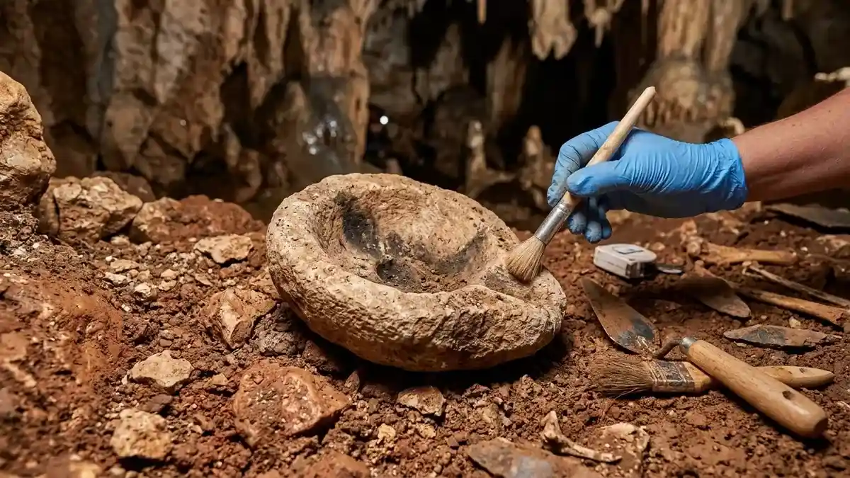
The high-definition digital rendering has also allowed scientists to re-examine critical archaeological artifacts found within La Pileta with a fresh set of eyes. Among the most remarkable items highlighted by the project is an ancient stone lamp dating back to the Gravettian period.
Discovered deep within the cave’s interior, this primitive device still retains distinct chemical residues of ancient pigments. It stands as one of the absolute earliest recorded lighting devices ever discovered on the Iberian Peninsula.

[Fat / Oil Fuel Source] + [Plant Fiber Wick] ──► Portable Subterranean Flame
                                                           │
                                                           ▼
                                         Illuminated Deep Cave Walls for Artists
Thousands of years ago, prehistoric artists did not paint in the dark. They used these portable stone bowls, filled with animal fat or vegetable oils and fitted with a plant-fiber wick, to cast a warm, flickering light across the rock faces. This ancient technology allowed them to navigate treacherous pits and transform pitch-black, hidden chambers into sacred art galleries.
Today, a beautiful historical parallel has emerged: an ancient canvas that was once illuminated only by the dim smoke of a stone lamp can now be explored across the globe using the bright, digital pixels of a smartphone screen.
A Game-Changer for Global Conservation and Education
Beyond its immense value to pure archaeological science, the digital preservation of La Pileta Cave marks a massive leap forward in cultural heritage management. It creates a win-win scenario for both conservationists and the public.
Risk-Free Academic Study
The creation of an incredibly accurate virtual world means that international scholars can thoroughly analyze fragile Paleolithic paintings, trace faint line engravings, and measure geological formations from their home laboratories. They can conduct world-class research without ever stepping foot inside the cave, completely removing the threats of carbon dioxide buildup, lint shedding, and ambient heat introduced by human crowds.
Democratizing Global Access
For the general public, interactive digital models break down geographic and physical boundaries. People who cannot travel to southern Spain, or individuals with mobility constraints who cannot navigate steep, slippery underground cave trails, can now take an immersive, virtual walk through this prehistoric sanctuary.
Furthermore, this multi-disciplinary dataset provides a rich, multi-layered resource for professionals working across a variety of scientific fields:
Geologists can analyze the intricate karstic formations and stalactite growth patterns to track historical shifts in groundwater flow.
Biologists can study the deep-cave environments and map subterranean ecosystems safely.
Educators can use interactive models to bring history alive in classrooms, allowing students to explore humanity’s deep past firsthand.
The Frontier of Low-Cost Cave Archaeology
Led by an interdisciplinary team from the University of Seville in close collaboration with scientific researchers from Portugal, this project officially validates the expanding power of accessible consumer tech in field science.
Mobile LiDAR, which was once heavily dismissed by traditionalists due to early technical constraints and software bugs, has officially matured into an effective, low-cost, and highly versatile tool for speleology (the scientific study of caves) and field archaeology. By proving that consumer smartphones can accurately supplement industrial-grade scanners, the project opens the door for underfunded archaeological teams around the world to sustainably document and protect fragile, threatened historical sites before they are lost to time.
Frequently Asked Questions
What is La Pileta Cave and why is it famous?
La Pileta Cave is a world-renowned archaeological site located in Benaoján, Málaga, Spain. It is famous for housing one of Europe’s largest and most continuous collections of prehistoric rock art, containing thousands of paintings and symbols spanning a 100,000-year timeline from the Upper Paleolithic to the Bronze Age.
How did researchers make a 3D model of the cave?
The research team blended two distinct technologies: a tripod-mounted Terrestrial Laser Scanner (TLS) to establish a highly precise, millimeter-accurate foundational map, and hand-held smartphone LiDAR sensors to navigate, scan, and texture the narrow, hard-to-reach crawlspaces.
What did the ancient artists use to see inside the dark cave?
Archaeologists discovered a rare stone lamp dating back to the Gravettian period inside La Pileta. This ancient device, which still carries physical pigment residues, used burning animal fats or plant oils to provide portable light, allowing prehistoric humans to paint deep underground.
Why is digital scanning important for cave conservation?
Human presence alters the delicate climate inside caves. Breath increases humidity, body heat raises temperatures, and footsteps tracking in external dirt can trigger the growth of destructive algae on ancient paintings. A 3D model allows scientists to study the cave safely without physically entering it.
Can the public access this digital model?
Yes. The high-definition digital reconstruction is designed to be used as an educational and interactive tool, allowing people across the globe to virtually explore and “visit” the prehistoric chambers of La Pileta from their computers or mobile devices.