Table of Contents
- 1. Unlocking the Secrets of Sugarloaf Hill
- 1.1. Mapping the Woorinen Formation
- 2. The Middle Holocene Economic Boom
- 3. Chemical Fingerprinting and the Ancient Trading Superhighway
- 4. Chemical Profiling: The Next Frontier
- 5. Preserving Living Cultural Heritage
- 6. Conclusion
- 7. Frequently Asked Questions
- 7.1. 1. What is the Sugarloaf Hill Quarry and where is it located?
- 7.2. 2. How did scientists determine that the quarry was used for 7,000 years?
- 7.3. 3. What specific materials did Aboriginal people mine at this site?
- 7.4. 4. How do we know these stones were traded across long distances?
- 7.5. 5. What is a “chemical fingerprint” in archaeology and how will it be used next?
Ancient Stone Quarry Proves Aboriginal Communities Mined for 7,000 Years
The deep history of Australia is frequently viewed through a singular lens of nomadic hunter-gatherer traditions. While seasonal movement was a core element of traditional life, groundbreaking new archaeological research is proving that Indigenous communities also engaged in highly structured, long-term resource management and industrial-scale raw material extraction.
A collaborative study has successfully dated an ancient Aboriginal stone quarry along South Australia’s Murray River, confirming that Indigenous populations systematically mined the site for at least 7,000 years. The discovery fills a massive gap in the archaeological record of the southwestern Murray-Darling Basin, offering an unprecedented look at prehistoric tool manufacturing, long-distance trade networks, and intense economic cooperation that thrived millennia before European contact.

Ancient Stone Quarry Proves Aboriginal Communities Mined for 7,000 Years
Unlocking the Secrets of Sugarloaf Hill
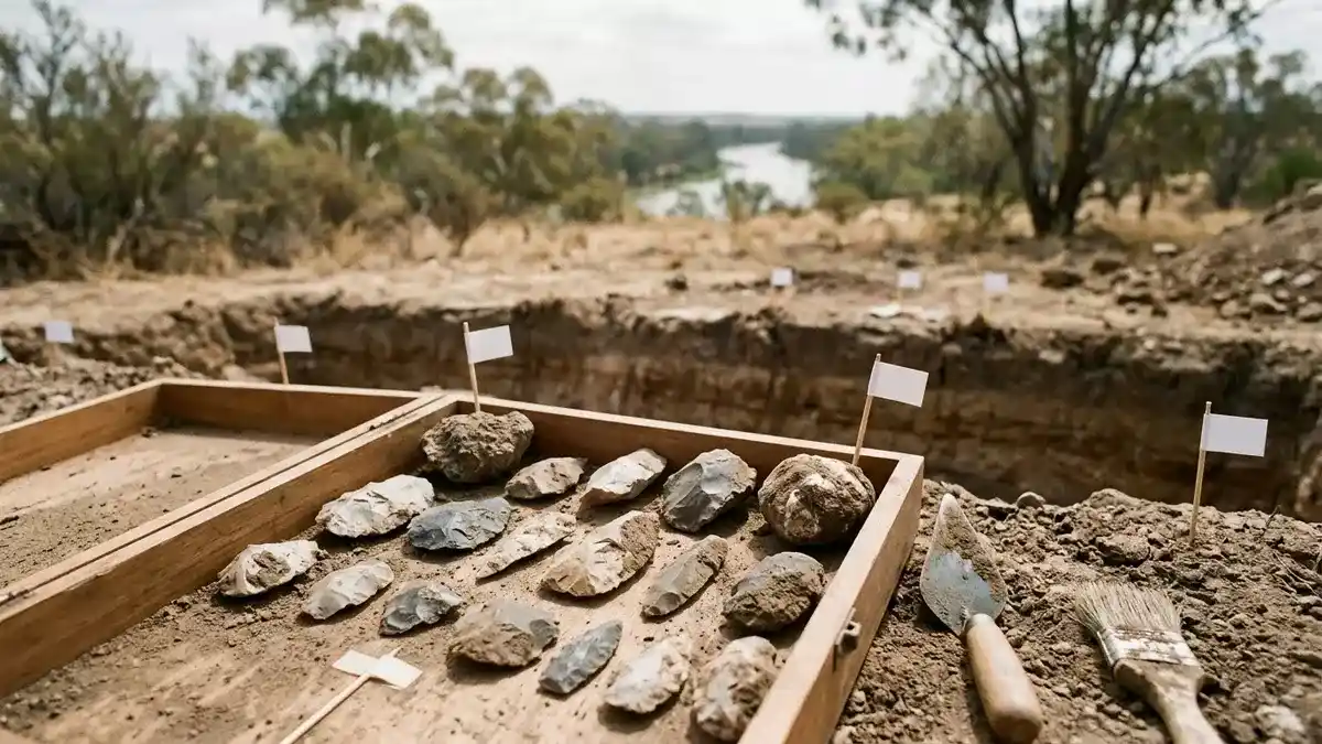
The focal point of this major archaeological milestone is the Sugarloaf Hill Quarry, located near Overland Corner in South Australia’s Riverland region. For generations, local Aboriginal communities and researchers knew of the quarry’s existence, but until now, little scientific work had been conducted to pinpoint when the mining actually began or how the site anchored the broader regional economy.
 Inca Empire (Quiz)
To establish an ironclad chronological timeline, an interdisciplinary research team from Flinders University worked hand-in-hand with the River Murray and Mallee Aboriginal Corporation. The team utilized an array of modern dating methods to analyze both the recovered stone artifacts and the surrounding geological strata.
Mapping the Woorinen Formation
The geological data revealed that the ancient miners focused their efforts on a specific landscape feature known as the Woorinen Formation. Exposed by both natural erosion and historical road cuttings, this specific layer provided the miners with direct access to highly prized subterranean veins of silcrete and chert.
[Woorinen Formation Strata] ➔ [Targeted Indigenous Mining] ➔ [Extraction of High-Grade Silcrete & Chert]
Silcrete and chert are exceptionally hard, fine-grained sedimentary rocks. For an ancient toolkit, these materials were the equivalent of high-grade steel. When fractured intentionally using a process called flintknapping, these stones produce incredibly sharp, durable edges, making them the ideal raw material for manufacturing heavy-duty wood-working tools, hunting weapons, skinning knives, and domestic processing gear.
The Middle Holocene Economic Boom
The dating results securely place the origins of the Sugarloaf Hill mining operations roughly 7,000 years in the past, pushing the site’s history deep into the Middle Holocene epoch. Interestingly, this scientific timeline aligns perfectly with a broader societal transformation observed along the Murray River during the exact same period.
Archaeologists have noted that around 7,000 years ago, the Middle Holocene brought about a significant shift in how Aboriginal groups interacted, traded, and structured their societies. The opening of the Sugarloaf Hill Quarry coincided with a regional economic and cultural boom characterized by:
Growing Exchange Networks: A sharp increase in the movement of goods up and down major river systems.
Established Cemeteries: The appearance of formal, recurring burial grounds, signaling strong, multi-generational territorial attachments to specific stretches of the river.
Large Oven Mounds: The construction of massive earth oven mounds used to process bulk quantities of food, particularly nutrient-rich aquatic plants like bullrush roots.
Proliteration of Grinding Stones: A dramatic increase in heavy stone tools used to mill seeds and process materials, indicating more intensive food production and larger group gatherings.
Together, these archaeological markers point to an era of population growth, increased social complexity, and a highly organized system of intergroup alliances held together by shared access to critical resources.
Chemical Fingerprinting and the Ancient Trading Superhighway
One of the most compelling aspects of the Sugarloaf Hill study is what it reveals about ancient Australian geography. High-quality silcrete and chert sources are not distributed evenly across the continent. In fact, within this section of the country, these specific stone deposits occur only within a very narrow, localized geographic band running along the Murray River between Berribee in northwestern Victoria and Overland Corner in South Australia.
Despite this localized source, finished tools made from this specific Riverland stone routinely turn up in archaeological excavations hundreds of miles away, far outside the natural geological limits of the stone formations.
[Sugarloaf Hill Quarry] ➔ [Raw Material Extraction] ➔ [Long-Distance Trade Networks] ➔ [Lower Murray Communities]
This wide geographic spread provides undeniable physical proof of a long-distance trading superhighway operating across the Murray-Darling Basin. Rather than traveling all the way to Sugarloaf Hill themselves, distant communities acquired the prized material through complex, multi-tiered hand-to-hand exchange networks. The stone functioned as a high-value trade commodity, exchanged between different ancestral groups to cement diplomatic ties, facilitate marriages, and secure access to seasonal hunting grounds.
Chemical Profiling: The Next Frontier
While the current study, published in the prestigious journal Archaeology in Oceania, has locked in the 7,000-year timeline, the research team is already preparing for the next phase of the project. Lead author Dr. Craig Westell explained that the future of the initiative relies heavily on advanced laboratory chemical and isotopic testing.
By mapping the unique trace elements and geochemical signatures—effectively the “chemical fingerprint”—of the stone at Sugarloaf Hill, researchers can compare the quarry’s profile directly against thousands of stone tools stored in museum collections across Australia. This advanced matching process will allow scientists to trace the exact route each artifact traveled from its birth in the Riverland clay to its final resting place, mapping out the precise boundaries of ancient Indigenous commercial routes with pinpoint accuracy.
Preserving Living Cultural Heritage
Beyond its immense academic and scientific value, the research team stresses that these ancient quarries hold profound spiritual and cultural importance for modern Indigenous traditional owners. For Aboriginal communities, stone quarries are not just abandoned industrial workspaces; they are living monuments that embody long-standing, unbroken ties to country, ancestral spirits, and traditional ownership.
The physical marks left on the landscape by thousands of years of human hands are a tangible record of ancestral industry. The authors hope that by providing rigorous scientific validation of the site’s immense antiquity, this study will bolster community-led conservation efforts, ensuring that these invaluable heritage places receive the highest level of legal protection and care for generations to come.
Conclusion
The stones of Sugarloaf Hill have provided the global scientific community with a monumental look into Australia’s deep past. By proving that a single quarry consistently supplied raw materials to an interconnected network of river communities for 7,000 years, this research challenges old stereotypes of prehistoric isolation. It replaces them with a vibrant narrative of a sophisticated, highly organized ancient economy driven by resourcefulness, long-distance diplomacy, and enduring respect for the land.
Frequently Asked Questions
1. What is the Sugarloaf Hill Quarry and where is it located?
The Sugarloaf Hill Quarry is an ancient Aboriginal stone mining site located near Overland Corner in the Riverland region of South Australia, running along the historic Murray River. It served as a centralized source of high-quality stone for tool manufacturing for millennia.
2. How did scientists determine that the quarry was used for 7,000 years?
An international team of researchers from Flinders University and the River Murray and Mallee Aboriginal Corporation utilized multiple modern stratigraphic and archaeological dating methods to analyze the soil layers, geological formations, and excavated stone artifacts, tracing continuous mining activity back to the Middle Holocene.
3. What specific materials did Aboriginal people mine at this site?
The ancient miners targeted specific veins of silcrete and chert within the Woorinen Formation. These hard, fine-grained sedimentary rocks were highly valued because they could be precisely chipped and shaped into exceptionally sharp, durable edges, making them ideal for crafting weapons and utilitarian tools.
4. How do we know these stones were traded across long distances?
Silcrete and chert of this specific quality are geologically confined to a narrow stretch of the Murray River between South Australia and Victoria. However, finished tools composed of this exact stone have been unearthed in archaeological sites hundreds of miles outside this zone, proving they were moved via vast, long-distance Indigenous trade networks.
5. What is a “chemical fingerprint” in archaeology and how will it be used next?
A chemical fingerprint is the unique mix of trace elements and isotopic signatures found inside a specific rock formation. By profiling the stone at Sugarloaf Hill, scientists can screen stone tools found across Australia to see if they match the quarry’s unique signature, allowing them to map out ancient trade routes with absolute precision.