
Table of Contents
- 1. The Breakthrough Excavation at Primorsky Boulevard
- 2. Unearthing Ginestra: The 14th-Century Genoese Stronghold
- 3. The Ottoman Empire’s Sentinel: The Lost Castle of Hajibey
- 3.1. Solving a Two-Century-Old Archaeological Mystery
- 4. Going Deeper: The 5th-Century BCE Ancient Greek Roots
- 5. Odesa as a Historical Crossroads of Civilizations
- 6. Frequently Asked Questions
- 6.1. What major discovery was recently made in Odesa, Ukraine?
- 6.2. Where exactly were these fortresses found?
- 6.3. What artifacts were recovered from the medieval Genoese layer?
- 6.4. How was the exact location of Hajibey Castle finally confirmed?
- 6.5. Is there evidence of human history at the site older than the Middle Ages?
Lost Fortresses Confirmed Under Odesa Rewrites Black Sea History
For nearly two centuries, historians and archaeologists passionately debated the exact geographic footprint of Odesa’s pre-modern history. While the vibrant Ukrainian port city is widely celebrated for its late 18th-century classical architecture and imperial foundations, rumors of much older, subterranean strongholds lingered in historical records.
Now, those long-standing mysteries have finally been solved. A targeted archaeological expedition has successfully uncovered the physical remains of two long-lost fortresses directly beneath one of the city’s most iconic landmarks.
Hidden below the bustling pavements of Primorsky Boulevard and the famous monument dedicated to the Duke de Richelieu, researchers have verified the precise locations of the 14th-century Genoese trading post of Ginestra and the subsequent Ottoman imperial fortress of Hajibey. This multi-layered discovery fundamentally shifts our understanding of the region, proving that Odesa has served as a critical, fiercely contested geopolitical crossroads for thousands of years.
Lost Fortresses Confirmed Under Odesa Rewrites Black Sea History

The Breakthrough Excavation at Primorsky Boulevard
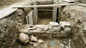
The historic discovery was spearheaded by a joint expedition featuring researchers from the South Ukrainian National Pedagogical University and the Institute of Archaeology of the National Academy of Sciences of Ukraine. Spurred by intriguing technological data, the team initiated a intensive three-week excavation concentrated around the square surrounding the Duke de Richelieu monument.
[ Subterranean Historical Layers - Odesa Excavation ]

  Surface Level: Modern Odesa & Duke de Richelieu Monument
  -------------------------------------------------------------
  Layer 1 (18th Century): Ottoman Fortress of Hajibey Ruins
  -------------------------------------------------------------
  Layer 2 (14th Century): Genoese Stronghold of Ginestra
  -------------------------------------------------------------
  Layer 3 (5th Century BCE): Ancient Greek Histrian Harbor
This specific urban zone had long been suspected of harboring deep-seated historical secrets, but the dense infrastructure of modern Odesa had previously prevented comprehensive subterranean exploration. The breakthrough finally came as a direct follow-up to a series of ground-penetrating radar scans conducted in 2021. Those initial non-invasive scans detected significant structural anomalies and dense geometric patterns deep beneath the public square.
When the archaeological team finally broke ground, their physical excavations perfectly validated the radar data. Just beneath the topsoil, they systematically cleared away centuries of earth to reveal a complex matrix of defensive walls, foundations, and domestic debris that documented alternating eras of maritime trade and military conflict.
Unearthing Ginestra: The 14th-Century Genoese Stronghold
The oldest medieval layer uncovered during the three-week dig belongs to the Republic of Genoa, a dominant maritime and commercial powerhouse during the Middle Ages. Archaeologists discovered clear cultural strata identifying the lost trading post known historically as Ginestra.
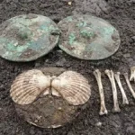
During the 14th century, Genoese merchants established an expansive network of fortified commercial outposts throughout the Black Sea basin. These hubs allowed the Italian maritime republic to monopolize lucrative regional trade routes connecting Europe, Byzantium, and the vast interior of Eastern Europe. The excavations under Primorsky Boulevard yielded undeniable physical evidence of this bustling medieval node, including imported Byzantine coins and distinctive, high-status Italian and Mediterranean ceramics.
The presence of Ginestra highlights a complex and often dark chapter in regional history. This outpost did not merely handle agricultural goods or textiles; it served as a primary node in the highly lucrative medieval slave trade. Genoese merchants leveraged these coastal strongholds to purchase captives from local conflicts and transport them across the Mediterranean, making Ginestra a vital financial asset for the Republic of Genoa before shifting geopolitical tides forced their withdrawal from the Black Sea.

The Ottoman Empire’s Sentinel: The Lost Castle of Hajibey
As Genoese influence waned in the 15th and 16th centuries, the expanding Ottoman Empire recognized the immense strategic value of the high cliffs overlooking the natural harbor. Over the remains of the old Italian trading post, the Ottomans constructed a formidable stronghold known as Hajibey Castle.
The recent excavations successfully exposed the structural remnants of a massive Ottoman coastal artillery battery. Measuring approximately 40 by 40 meters, this heavily fortified military installation was strategically positioned between the modern Duke monument, the city’s historic funicular railway, and the surrounding network of urban alleys. Constructed with thick stone walls engineered to withstand naval bombardments, the battery was built just a few meters from the edge of the steep coastal cliff.
          [ Hajibey Artillery Battery Tactical Layout ]

                    [ Black Sea Harbor ]
                             ^
                             |  (Cannon Fire Zone)
                             v
   =====================[ Cliff Edge ]=====================
   [ Stone Wall ]                                 [ Stone Wall ]
   [ Defense    ]    <-- 40 Meters Wide -->       [ Defense    ]
   [ Battery    ]                                 [ Battery    ]
   ========================================================
                Elevation: 32 Meters Above Sea Level
Perched at an elevation of 32 meters above sea level, the fortress granted Ottoman defenders an absolute tactical advantage. From this commanding vantage point, imperial gunners could effectively control entry to the harbor, track approaching maritime vessels, and rain cannon fire down upon the nearby ravines and beaches to repel amphibious assaults.
However, the fortress met a violent end. In 1789, during the intense Russo-Turkish Wars, Russian imperial forces captured Hajibey Castle. Seeking to erase the Ottoman military presence and prepare the landscape for a new imperial city, the conquering forces completely leveled the fortifications.
The current archaeological team found widespread evidence of this systematic destruction. The fortress walls had been deliberately dismantled, and much of the high-quality stone was salvaged and repurposed to build the foundations of early 19th-century Odesa. Amidst the discarded military debris and leveled earth, researchers recovered beautifully carved Ottoman pilaster capitals, broken military ceramics, and various bronze artifacts that showcase the daily life of the vanished garrison.
Solving a Two-Century-Old Archaeological Mystery
For nearly 200 years, the precise location and layout of Hajibey Castle remained one of the most frustrating blind spots in Black Sea historiography. Because the conquering military forces left no accurate structural maps of the site prior to its demolition, and because rapid urban development throughout the 19th and 20th centuries radically altered the topography, many scholars feared the fortress had been entirely obliterated.
Some historians argued that catastrophic coastal landslides had long since dropped the castle’s remnants into the sea. The discovery of these 18th-century architectural foundations, aligning flawlessly with rare historical sketches and regional maps, finally provides definitive proof of the fortress’s exact boundaries, layout, and defensive capabilities.
Going Deeper: The 5th-Century BCE Ancient Greek Roots
While the discovery of the medieval Italian and Ottoman fortresses would have been enough to cement the excavation’s historical importance, the team’s deep trenching revealed an even older chapter of human occupation. Beneath the medieval and early modern foundations, archaeologists broke through to cultural layers dating back to the 5th century BCE.
This deep layer produced artifact assemblages linked directly to the ancient Greek colonization of the Black Sea. Long before Italian merchants or Ottoman pashas viewed the cliffs as a military asset, classical Greek navigators recognized the spot as a premier maritime shelter, naming it the Histrian Harbor.
This ancient layer proves that the urban space occupied by modern Odesa has been operating as an international maritime sanctuary for more than 2,500 years. The ceramics, coins, and domestic refuse left behind by these ancient Greek traders demonstrate that the area’s role as a gateway between continental steppes and the wider Mediterranean world dates back to antiquity.
Odesa as a Historical Crossroads of Civilizations
The successful excavations under the Duke de Richelieu monument offer far more than a collection of premium artifacts; they provide undeniable proof of Odesa’s vibrant, multi-layered identity. The structural remains stack neatly on top of one another, physicalizing a timeline of competing global empires.
| Historical Era | Settlement/Structure Name | Primary Culture/Empire | Key Archaeological Findings |
| 5th Century BCE | Histrian Harbor | Ancient Greek Colonists | Classical Mediterranean trade pottery, ancient refuse layers |
| 14th Century CE | Ginestra | Republic of Genoa | Byzantine coins, imported Italian ceramics, trade records |
| 18th Century CE | Hajibey Castle | Ottoman Empire | 40x40m artillery battery, stone ramparts, carved pilaster capitals |
This unique urban stratigraphy tells a story of continuous destruction, adaptive reuse, and profound cultural synthesis. As trade monopolies shifted, empires fell, and fortresses were leveled, the incoming populations routinely utilized the physical infrastructure of their predecessors to construct the next era of history. The discovery reminds us that beneath the elegant, uniform European facades of modern Odesa lies a rich, tumultuous, and deeply diverse historical foundation shaped by Greek, Italian, and Ottoman hands.
Frequently Asked Questions
What major discovery was recently made in Odesa, Ukraine?
Archaeologists successfully located and excavated the physical remains of two historical strongholds buried directly beneath Odesa’s Primorsky Boulevard: the 14th-century Genoese trading fortress of Ginestra and the later 18th-century Ottoman fortress of Hajibey.
Where exactly were these fortresses found?
The ruins were uncovered during a targeted three-week excavation around the public square surrounding the well-known monument to the Duke de Richelieu, situated 32 meters above sea level along the city’s coastal cliffs.
What artifacts were recovered from the medieval Genoese layer?
Archaeologists recovered imported Byzantine coins and various Mediterranean ceramics. These artifacts confirm the site’s role as Ginestra, an active maritime trading post operated by the Republic of Genoa during the 14th century.
How was the exact location of Hajibey Castle finally confirmed?
The exact location had been a subject of dispute for 200 years due to a lack of surviving maps and extensive post-1789 demolition. Archaeologists confirmed its position by verifying anomalies detected during a 2021 ground-penetrating radar scan, uncovering a 40×40 meter Ottoman artillery battery made of stone.
Is there evidence of human history at the site older than the Middle Ages?
Yes. Excavators dug down to a deeper cultural layer dating back to the 5th century BCE. This layer corresponds to the ancient Greek settlement known as Histrian Harbor, showing that the site has been a hub of maritime commerce for over 2,500 years.