**Mamluk Water System and Mosque Discovered at Saladin Citadel**
Archaeologists have made a significant breakthrough near Cairo’s historic Saladin Citadel, uncovering an impressive Mamluk-era water supply network and a long-lost mosque. These finds shed fresh light on how medieval Cairo managed its vital water resources and supported daily life around one of Egypt’s most iconic fortresses.
The discoveries highlight the engineering ingenuity of the Mamluk period and reveal previously undocumented parts of Cairo’s famous aqueduct system. They offer a vivid glimpse into the infrastructure that sustained a bustling medieval metropolis.
Mamluk Water System and Mosque Discovered at Saladin Citadel
### Major Excavations Around the Citadel
A joint Egyptian-French archaeological mission, collaborating between Egypt’s Supreme Council of Antiquities and the French Institute for Oriental Archaeology (IFAO), led the work in the historic districts of Arab al-Yasar and al-Hattaba. These areas border the Saladin Citadel, a landmark that has stood as a center of power since the 12th century.
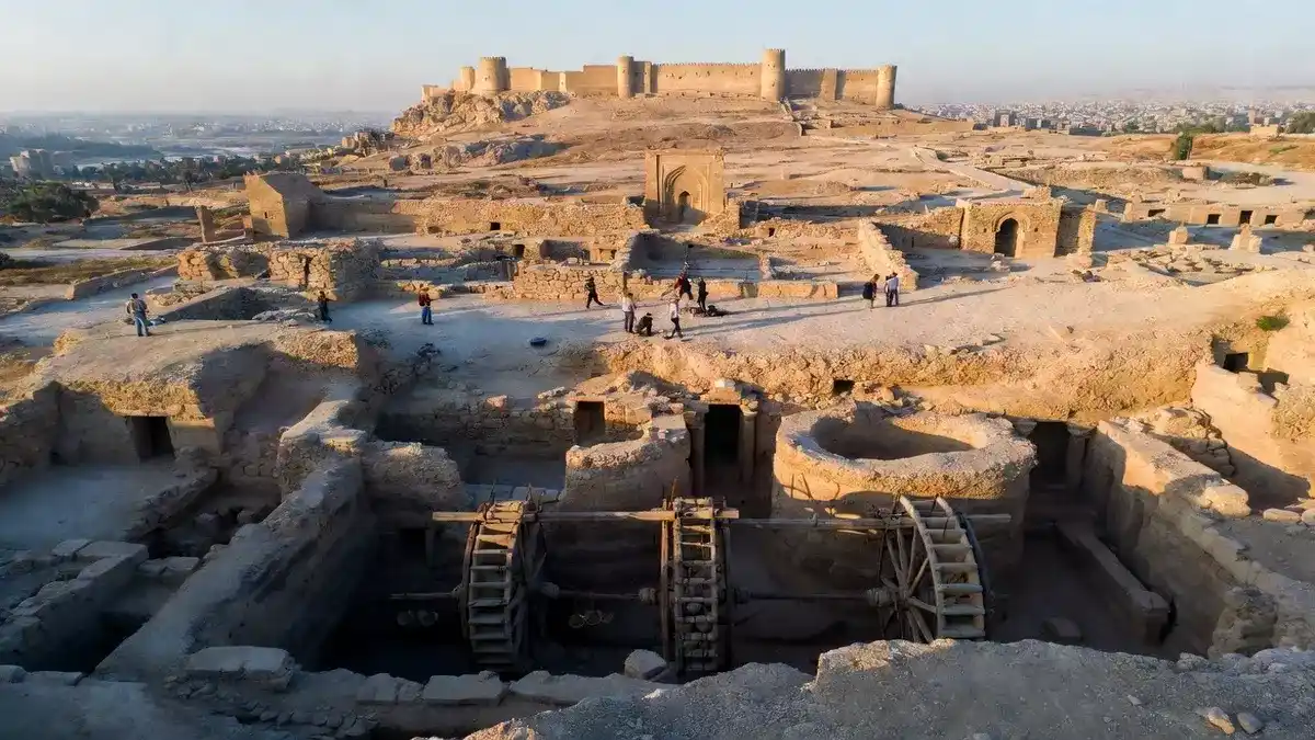
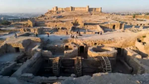
In Arab al-Yasar, researchers uncovered a complete hydraulic system from the Mamluk era. At its heart lie two massive stone wells, one plunging about 10 meters deep and the other roughly 8 meters. Excavation continues inside both wells as teams search for the original underground storage reservoirs that once held precious Nile water.

### Engineering Marvel of Medieval Water Management
The wells anchored a sophisticated network designed to lift water uphill toward the citadel. Four waterwheels, powered by animals, worked alongside stone channels to move water efficiently through the complex. This system connected directly to Cairo’s renowned aqueduct, the Sur Magra al-Oyoun, which supplied water across large sections of the city.
What makes this discovery particularly exciting is that historical texts had never described this final link in the chain. For the first time, archaeologists can see exactly how water moved from the main aqueduct into the citadel itself. The remains include animal pathways for operating the waterwheels, stables for the working animals, fodder storage rooms, watering basins, and stone-paved work areas.
These practical details paint a clear picture of the everyday labor required to keep water flowing in medieval Cairo. In a hot, arid environment, reliable water infrastructure was essential for survival, defense, and the functioning of a major political and military hub.
Preliminary analysis links some of the installations to major building campaigns under Sultan al-Nasir Muhammad ibn Qalawun, a powerful Mamluk ruler known for ambitious construction projects. During the current season, the team also identified a new water channel heading westward toward the royal stables, which may help date surrounding structures more precisely.
### Mamluk Mosque and Burial Ground Revealed
Excavations in the nearby al-Hattaba district revealed the foundations of a Mamluk-era mosque. Key architectural elements include the qibla iwan, the mihrab prayer niche, portions of the southwestern arcade, and original stone flooring. These features provide valuable insight into religious architecture of the period.
Nearby, archaeologists found a burial chamber and multiple graves spanning different Islamic eras. Human skeletal remains recovered from the site add a personal dimension to the area’s history. One tomb dates back to the early Islamic period, demonstrating the long, layered occupation of this strategically important zone near the citadel.
### Artifacts and Digital Documentation Efforts
The mission has recovered a rich array of artifacts that bring the site to life. These include ceramic buckets once attached to waterwheels, coins from both Mamluk and Ottoman times, metal seals, jewelry, everyday household objects from the 18th and 19th centuries, and even fragments of weapons.
In addition to traditional digging, the team is creating detailed three-dimensional digital models of monuments, including the Khanqah al-Nizamiyya, where more architectural remains emerged. They have also documented various Mamluk and Ottoman tombs within the complex.
A comprehensive digital database now preserves excavation records, architectural data, and historical context related to the Saladin Citadel and its surroundings. The project doubles as a training initiative for Egyptian inspectors of Islamic antiquities, teaching modern methods in excavation, documentation, photography, and digital recording.
### Historical Significance of the Saladin Citadel
Built by the renowned Muslim leader Saladin (Salah al-Din) in the late 12th century, the Citadel served as Egypt’s seat of government for centuries. During the Mamluk period (1250–1517), it became a thriving center of military, political, and cultural activity. The Mamluks, originally slave soldiers who rose to power, were master builders and engineers who left an indelible mark on Cairo’s landscape.
Water management was a constant challenge in the region. The Nile River provided the lifeblood, but lifting and distributing water to elevated areas like the Citadel required clever solutions. The newly discovered system demonstrates advanced hydraulic knowledge and organized labor that supported both the fortress and surrounding communities.
This discovery fills important gaps in our understanding of how the citadel’s water supply functioned in its final stages. It also underscores the continued archaeological potential of Cairo’s historic neighborhoods, where layers of history remain buried beneath modern life.
### Why These Finds Matter Today
The Mamluk water system and mosque add substantial evidence to the story of urban development around the Saladin Citadel. They illustrate the interplay between infrastructure, religion, and burial practices over several centuries. Such finds help historians reconstruct daily life, economic activities, and technological achievements in one of the medieval world’s greatest cities.
Modern technology plays a crucial role here. Digital modeling and systematic recording ensure that these fragile remains are preserved for future generations, even as excavation continues. The training component also builds local expertise, strengthening Egypt’s capacity to protect and study its rich Islamic heritage.
As Cairo grows and develops, projects like this remind us of the importance of balancing urban progress with archaeological preservation. The neighborhoods around the Citadel still hold many secrets, offering exciting opportunities for future research.
### Broader Context of Mamluk Achievements
The Mamluk Sultanate was a golden age for architecture and engineering in Egypt. Rulers invested heavily in mosques, madrasas, aqueducts, and fortifications. Discoveries like this one help scholars better appreciate the scale and sophistication of these efforts.
The water system, in particular, reflects a society that understood hydrology, animal power, and urban planning. Connecting it to the Sur Magra al-Oyoun aqueduct shows how different parts of the city worked together as an integrated system.
Meanwhile, the mosque and burials highlight the spiritual and communal aspects of life near the seat of power. Together, these elements create a more complete picture of medieval Cairo as a dynamic, multifaceted urban center.
### Conclusion: Illuminating Medieval Cairo’s Hidden Past
The unearthing of this Mamluk-era water system and mosque near Saladin Citadel represents an important advancement in Egyptian archaeology. These structures bring us closer to understanding the engineering, daily operations, and religious life that sustained one of history’s most enduring power centers.
Through careful excavation, scientific analysis, and digital preservation, researchers continue to reveal the sophistication of Mamluk society. This work not only enriches our knowledge of the past but also ensures that Cairo’s extraordinary heritage remains accessible for generations to come.
As more details emerge from ongoing excavations, we can expect even deeper insights into how medieval Egyptians harnessed technology and community to thrive in a challenging environment. The Saladin Citadel and its surroundings still have many stories to tell.
### FAQ: Mamluk Discoveries Near Saladin Citadel
**What is the Mamluk period in Egyptian history?**
The Mamluk era lasted from 1250 to 1517 CE. It was a time when former slave soldiers established a powerful sultanate known for military strength, grand architecture, and advanced infrastructure projects across Egypt and beyond.
**How did the discovered water system work?**
Animal-powered waterwheels lifted water from deep stone wells and channeled it uphill through stone conduits toward the Citadel. The system connected to the larger Sur Magra al-Oyoun aqueduct, delivering water efficiently to elevated areas.
**Why is the connection to the aqueduct important?**
This section had never been documented in historical records. The excavation reveals for the first time how water was transferred from the main aqueduct directly into the Citadel complex.
**What was found inside the mosque excavation?**
Archaeologists uncovered the qibla iwan, mihrab, parts of the arcade, stone flooring, and nearby burials spanning multiple Islamic periods, including early Islamic and Mamluk graves.
**What artifacts were recovered during the project?**
Finds include ceramic waterwheel buckets, Mamluk and Ottoman coins, metal seals, jewelry, household items, and weapon fragments, offering clues about daily life across several centuries.
**How is modern technology helping this project?**
The team creates 3D digital models, builds comprehensive databases, and uses advanced recording methods. The project also trains Egyptian archaeologists in contemporary excavation and documentation techniques.